IMAGES TAKEN NEAR TO
ARISAIG, PH39 4NS
Introduction
This page details the photographs taken nearby to PH39 4NS by members of the Geograph project.
The Geograph project started in 2005 with the aim of publishing, organising and preserving representative images for every square kilometre of Great Britain, Ireland and the Isle of Man.

There are currently over 7.5m images from over14,400 individuals and you can help contribute to the project by visiting https://www.geograph.org.uk
Image Map
Images are licensed for reuse under creativecommons.org/licenses/by-sa/2.0
Notes
- Clicking on the map will re-center to the selected point.
- The higher the marker number, the further away the image location is from the centre of the postcode.
Image Listing (26 Images Found)
Images are licensed for reuse under creativecommons.org/licenses/by-sa/2.0
Image
Details
Distance
1
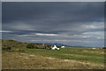
Eigg and Rum beyond Back of Keppoch, from the Road to the Isles
Image: © David Long
Taken: 29 Apr 2009
0.01 miles
2
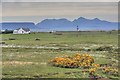
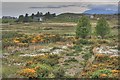
Gorse, Cottongrass and Rum
Looking across the western extremity of the flat, low lying land known as Mointeach Mhòr (the Big Moss) which traditionally provided peat for fuel for the local crofting communities.
Image: © Mick Garratt
Taken: 28 May 2008
0.06 miles
3
View towards Mointeach Mh?r
A big boggy plain between Loch Morar and Arisaig,
Image: © Richard Webb
Taken: 21 Dec 2015
0.08 miles
4
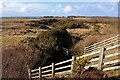
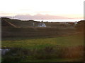
Scrubby moorland at Kinloid
A culvert under the A830.
Image: © Alan Reid
Taken: 6 Mar 2017
0.09 miles
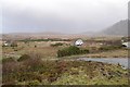
5
View Towards Bunacaimb
Across the western edge of Mointeach Mhòr (the Big Moss).
Image: © Mick Garratt
Taken: 28 May 2008
0.11 miles
6
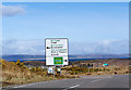
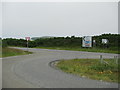
The road junctionnorth of Arisaig
The signs in Gaelic says it all. You are in the highlands. Skye is in the background.
Image: © Frank Garvock
Taken: 22 Mar 2008
0.14 miles
8
Kinloid: R?m view at sunset
Looking northwest from Kinloid, we see the junction of the B8008 with the A830 in the foreground, with the distinctive silhouette of the Isle of Rùm on the horizon.
Image: © Chris Downer
Taken: 3 Aug 2008
0.16 miles
10
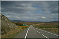
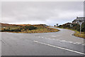
Sign for the even-more-scenic Road to the Isles
Earlier improvements to the A830 have diverged more radically from the road, which has been redesignated as the B8008.
Image: © David Long
Taken: 29 Apr 2009
0.16 miles