IMAGES TAKEN NEAR TO
LOCHAILORT, PH38 4NA
Introduction
This page details the photographs taken nearby to PH38 4NA by members of the Geograph project.
The Geograph project started in 2005 with the aim of publishing, organising and preserving representative images for every square kilometre of Great Britain, Ireland and the Isle of Man.

There are currently over 7.5m images from over14,400 individuals and you can help contribute to the project by visiting https://www.geograph.org.uk
Image Map
Images are licensed for reuse under creativecommons.org/licenses/by-sa/2.0
Notes
- Clicking on the map will re-center to the selected point.
- The higher the marker number, the further away the image location is from the centre of the postcode.
Image Listing (28 Images Found)
Images are licensed for reuse under creativecommons.org/licenses/by-sa/2.0
Image
Details
Distance
1
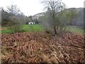
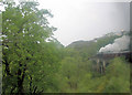
View from a Fort William-Mallaig train - House in the woods
The manicured lawn contrasts with the wild surroundings. Smoke drifts past from the steam engine which is hauling the train.
Image: © Nigel Thompson
Taken: 26 Apr 2018
0.06 miles
2

The line to Mallaig
Taken from the bridge carrying a track from Polnish; the bridge appears to straddle the square boundary.
Image: © Nigel Brown
Taken: 4 Jun 2000
0.08 miles
3
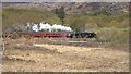
The Jacobite returns to Fort William
The waters of Lochan Deabhta visible in the foreground.
Image: © Gordon Brown
Taken: 28 Apr 2024
0.10 miles
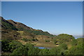
4
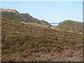
Looking west to Loch Beag
An inlet of Loch Nan Uamh.
Image: © M J Richardson
Taken: 17 May 2013
0.10 miles
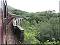
6
Arnabol Viaduct
Locomotive No. 45231 'Sherwood Forester' hauls 'The Jacobite' excursion train north over this viaduct.
Image: © Stuart Logan
Taken: 1 Jun 2011
0.12 miles
9
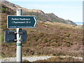
Scottish Rights of Way and Access Society sign
To Peathan Meadhonach/Peanmeanach ruins. 3.5 miles away in Ardnish Image
Image: © M J Richardson
Taken: 17 May 2013
0.13 miles
10
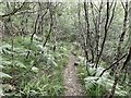
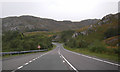
Peameanach Path
The path to Peanmeanach was built over a hundred years ago and would have been used daily by the children going to school at Upper Polnish. It was maintained by two road builders, who were partly paid for by the crofters. This caused considerable aggravation.
Image: © Mick Garratt
Taken: 19 Aug 2015
0.14 miles