IMAGES TAKEN NEAR TO
Ardtoe, ACHARACLE, PH36 4LD
Introduction
This page details the photographs taken nearby to PH36 4LD by members of the Geograph project.
The Geograph project started in 2005 with the aim of publishing, organising and preserving representative images for every square kilometre of Great Britain, Ireland and the Isle of Man.

There are currently over 7.5m images from over14,400 individuals and you can help contribute to the project by visiting https://www.geograph.org.uk
Image Map
Images are licensed for reuse under creativecommons.org/licenses/by-sa/2.0
Notes
- Clicking on the map will re-center to the selected point.
- The higher the marker number, the further away the image location is from the centre of the postcode.
Image Listing (14 Images Found)
Images are licensed for reuse under creativecommons.org/licenses/by-sa/2.0
Image
Details
Distance
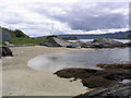
1
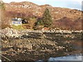
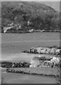
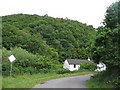
Between Gobshealach and Ardtoe
House and shoreline between Gobshealach and Ardtoe. On the 1940's map the road ended here
Image: © Jim Bain
Taken: 19 Feb 2006
0.13 miles
2
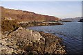
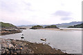
Shoreline, Tralee
Outer Kentra Bay, which does not dry at low water. There is a jetty here.
Image: © Richard Webb
Taken: 24 Feb 2018
0.14 miles
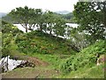
5
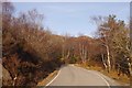
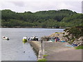
Cottage beneath Tor Luinngeanach
The Ardtoe road running through woodland.
Image: © Richard Webb
Taken: 5 Jul 2008
0.19 miles
10
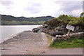
Woodland, Tor Luinngeanach
Oak woods at the mouth of Kentra Bay.
Image: © Richard Webb
Taken: 5 Jul 2008
0.20 miles