IMAGES TAKEN NEAR TO
ACHARACLE, PH36 4JZ
Introduction
This page details the photographs taken nearby to PH36 4JZ by members of the Geograph project.
The Geograph project started in 2005 with the aim of publishing, organising and preserving representative images for every square kilometre of Great Britain, Ireland and the Isle of Man.

There are currently over 7.5m images from over14,400 individuals and you can help contribute to the project by visiting https://www.geograph.org.uk
Image Map
Images are licensed for reuse under creativecommons.org/licenses/by-sa/2.0
Notes
- Clicking on the map will re-center to the selected point.
- The higher the marker number, the further away the image location is from the centre of the postcode.
Image Listing (7 Images Found)
Images are licensed for reuse under creativecommons.org/licenses/by-sa/2.0
Image
Details
Distance
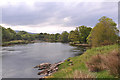
1
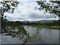
River Shiel
Looking upstream by Shielfoot.
Image: © John Allan
Taken: 1 Jul 2006
0.05 miles
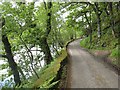
3
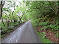
Minor road beside River Shiel
Looking north-westward.
Image: © Peter Wood
Taken: 26 May 2024
0.13 miles
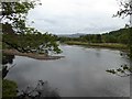
5
Road to Dorlinn
This single track road beside the River Shiel can often be busy with visitors to Castle Tioram.
Image: © Richard Webb
Taken: 6 Jun 2009
0.16 miles
6
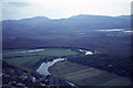
On Beinn Gheur near Doirlinn - View towards Shielfoot & Kentra Moss
Image: © Colin Park
Taken: 18 May 1975
0.17 miles
7
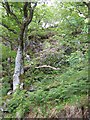
Oak woods opposite Shielfoot
Oak woods with the inevitable rhododendron above the road to Castle Tioram.
Image: © Richard Webb
Taken: 6 Jun 2009
0.18 miles