IMAGES TAKEN NEAR TO
Strontian, ACHARACLE, PH36 4HX
Introduction
This page details the photographs taken nearby to PH36 4HX by members of the Geograph project.
The Geograph project started in 2005 with the aim of publishing, organising and preserving representative images for every square kilometre of Great Britain, Ireland and the Isle of Man.

There are currently over 7.5m images from over14,400 individuals and you can help contribute to the project by visiting https://www.geograph.org.uk
Image Map
Images are licensed for reuse under creativecommons.org/licenses/by-sa/2.0
Notes
- Clicking on the map will re-center to the selected point.
- The higher the marker number, the further away the image location is from the centre of the postcode.
Image Listing (12 Images Found)
Images are licensed for reuse under creativecommons.org/licenses/by-sa/2.0
Image
Details
Distance
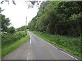
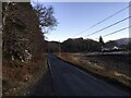
1

New bridge over Bun Allt Eachin
The bridge replaces an older version of the access to Bunalteachan.
Image]
Image: © John Haynes
Taken: 4 Jul 2016
0.02 miles
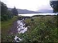
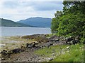
3

The north shore of Loch Sunart
The Bun Allt Eachin joins Loch Sunart at this point emerging from under the bridge on the left.
Image]
Image: © John Haynes
Taken: 4 Jul 2016
0.03 miles
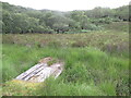
4
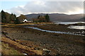
Loch Sunart shoreline
The burn in the foreground is Allt Eachain. The house beyond, and just outside this square is Bunalleachan.
Image: © Peter Bond
Taken: 27 Nov 2008
0.03 miles
9
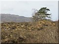
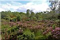
Woodland, Bunalteachan
Scattered trees and boggy ground beside Loch Sunart.
Image: © Richard Webb
Taken: 17 Apr 2014
0.17 miles