IMAGES TAKEN NEAR TO
Morrison Avenue, SPEAN BRIDGE, PH34 4ED
Introduction
This page details the photographs taken nearby to Morrison Avenue, PH34 4ED by members of the Geograph project.
The Geograph project started in 2005 with the aim of publishing, organising and preserving representative images for every square kilometre of Great Britain, Ireland and the Isle of Man.

There are currently over 7.5m images from over14,400 individuals and you can help contribute to the project by visiting https://www.geograph.org.uk
Image Map
Images are licensed for reuse under creativecommons.org/licenses/by-sa/2.0
Notes
- Clicking on the map will re-center to the selected point.
- The higher the marker number, the further away the image location is from the centre of the postcode.
Image Listing (42 Images Found)
Images are licensed for reuse under creativecommons.org/licenses/by-sa/2.0
Image
Details
Distance

3
The A86, Spean Bridge
The main road passing through Spean Bridge, the A86. A postbox is gradually being buried in the hedge on the opposite side of the road.
Image: © Graham Robson
Taken: 17 Jun 2018
0.16 miles
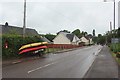
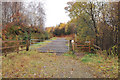
4
Play park, Spean Bridge
A play park beside the main road passing through the village of Spean Bridge.
Image: © Graham Robson
Taken: 17 Jun 2018
0.16 miles
5
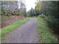
Track in Killiechonate Woodlands
Looking south-westward.
Image: © Peter Wood
Taken: 22 Sep 2019
0.17 miles

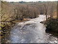
9
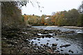
River Spean
The Spean flowing down to Spean Bridge.
Image: © Andrew Wood
Taken: 1 Nov 2008
0.19 miles