IMAGES TAKEN NEAR TO
Columba Court, FORT WILLIAM, PH33 7QA
Introduction
This page details the photographs taken nearby to Columba Court, PH33 7QA by members of the Geograph project.
The Geograph project started in 2005 with the aim of publishing, organising and preserving representative images for every square kilometre of Great Britain, Ireland and the Isle of Man.

There are currently over 7.5m images from over14,400 individuals and you can help contribute to the project by visiting https://www.geograph.org.uk
Image Map
Images are licensed for reuse under creativecommons.org/licenses/by-sa/2.0
Notes
- Clicking on the map will re-center to the selected point.
- The higher the marker number, the further away the image location is from the centre of the postcode.
Image Listing (7 Images Found)
Images are licensed for reuse under creativecommons.org/licenses/by-sa/2.0
Image
Details
Distance
1
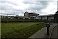
Lochyside Primary School
The school buildings are being demolished after Lochyside and Fort William Catholic primaries were merged as St Columba's Primary.
Image: © Richard Webb
Taken: 3 Jun 2017
0.13 miles
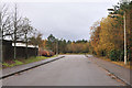
2
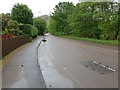
Kilmallie Road (B8006) at Lochyside
Looking south-eastward.
Image: © Peter Wood
Taken: 26 May 2019
0.13 miles
4
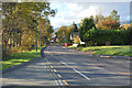
Kilmallie Road, Lochyside
A bus stop outside the site of Lochyside Primary School which was being demolished. Election material is still allowed on lampposts here.
Image: © Richard Webb
Taken: 3 Jun 2017
0.16 miles
5
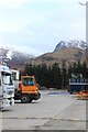
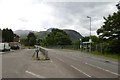
Lochyside industrial estate
Industrial estate with superb views of the Nevis hills.
Image: © edward mcmaihin
Taken: 7 Apr 2010
0.16 miles
7
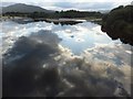
Reflections in still evening waters
The River Lochy divides around Eilean Mor, a view seen to advantage from the railway crossing.
Image: © Alan Bowring
Taken: 16 Aug 2012
0.25 miles