IMAGES TAKEN NEAR TO
Blar Mhor Industrial Estate, FORT WILLIAM, PH33 7PT
Introduction
This page details the photographs taken nearby to Blar Mhor Industrial Estate, PH33 7PT by members of the Geograph project.
The Geograph project started in 2005 with the aim of publishing, organising and preserving representative images for every square kilometre of Great Britain, Ireland and the Isle of Man.

There are currently over 7.5m images from over14,400 individuals and you can help contribute to the project by visiting https://www.geograph.org.uk
Image Map
Images are licensed for reuse under creativecommons.org/licenses/by-sa/2.0
Notes
- Clicking on the map will re-center to the selected point.
- The higher the marker number, the further away the image location is from the centre of the postcode.
Image Listing (11 Images Found)
Images are licensed for reuse under creativecommons.org/licenses/by-sa/2.0
Image
Details
Distance
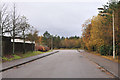
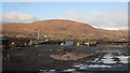
2
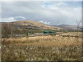
Lochyside industrial estate
Industrial estate with superb views of the Nevis hills.
Image: © edward mcmaihin
Taken: 7 Apr 2010
0.08 miles
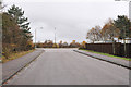
4
Fort William Police and Ambulance Station, Bl?r M?r
This police and ambulance station was opened in February 2014. It was built in a partnership between Police Scotland and the Scottish Ambulance Service.
Lochaber High School is visible behind to the right, with Ben Nevis and Aonach Mòr beyond.
Image: © Craig Wallace
Taken: 30 May 2016
0.16 miles
5
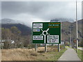
The A830 crosses Corpach Moss
With the road sign showing a sign of development to come - the police station is there, but no sign of the super store, which has been planned for some time - see Image from 2013. Ben Nevis is in cloud beyond.
Image: © M J Richardson
Taken: 15 Apr 2017
0.17 miles
6
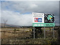
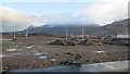
Land for Sale
Blàr Mòr, a development area, which seems to have been developing for some time without much progress, e.g., Image
Image: © M J Richardson
Taken: 15 Apr 2017
0.17 miles
7
Former Tesco site, Bl?r M?r
This area was bought by Tesco a few years ago, with plans to build a new supermarket. A roundabout was built for access, and some drainage has been constructed. But it seems Tesco have since abandoned this proposed development.
Last year the land was purchased by Highland Council, who are working with NHS Highland on plans to build a new hospital on the site.
Image: © Craig Wallace
Taken: 30 May 2016
0.18 miles
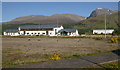
8
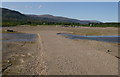
Bl?r M?r development site
A site destined for a superstore etc., but not much happening at the moment.
Image: © M J Richardson
Taken: 15 Apr 2017
0.19 miles
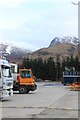
9
Construction, Bl?r M?r
Supermarket development on moss land.
Image: © Richard Webb
Taken: 1 Jan 2013
0.19 miles
10
Construction, Bl?r M?r
The flat bogland is being developed as a supermarket.
Image: © Richard Webb
Taken: 1 Jan 2013
0.20 miles