IMAGES TAKEN NEAR TO
FORT WILLIAM, PH33 7NN
Introduction
This page details the photographs taken nearby to PH33 7NN by members of the Geograph project.
The Geograph project started in 2005 with the aim of publishing, organising and preserving representative images for every square kilometre of Great Britain, Ireland and the Isle of Man.

There are currently over 7.5m images from over14,400 individuals and you can help contribute to the project by visiting https://www.geograph.org.uk
Image Map
Images are licensed for reuse under creativecommons.org/licenses/by-sa/2.0
Notes
- Clicking on the map will re-center to the selected point.
- The higher the marker number, the further away the image location is from the centre of the postcode.
Image Listing (5 Images Found)
Images are licensed for reuse under creativecommons.org/licenses/by-sa/2.0
Image
Details
Distance
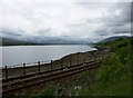
3

View from a Fort William-Mallaig train - Camas Cruinn, Loch Eil
Heading back towards Fort William.
Image: © Nigel Thompson
Taken: 26 Apr 2018
0.07 miles
5
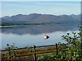
Boat on Loch Eil
The railing in the foreground runs alongside the Fort William to Mallaig railway line.
Image: © Dave Fergusson
Taken: 26 Sep 2010
0.21 miles