IMAGES TAKEN NEAR TO
FORT WILLIAM, PH33 7NF
Introduction
This page details the photographs taken nearby to PH33 7NF by members of the Geograph project.
The Geograph project started in 2005 with the aim of publishing, organising and preserving representative images for every square kilometre of Great Britain, Ireland and the Isle of Man.

There are currently over 7.5m images from over14,400 individuals and you can help contribute to the project by visiting https://www.geograph.org.uk
Image Map
Images are licensed for reuse under creativecommons.org/licenses/by-sa/2.0
Notes
- Clicking on the map will re-center to the selected point.
- The higher the marker number, the further away the image location is from the centre of the postcode.
Image Listing (4 Images Found)
Images are licensed for reuse under creativecommons.org/licenses/by-sa/2.0
Image
Details
Distance
2
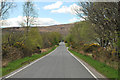
Field with daisies
The field lies between the minor road at Camaghael and the River Lochy, which is just beyond the trees at the far side of the grass.
Image: © Trevor Littlewood
Taken: 25 Apr 2017
0.14 miles
3
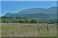
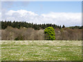
Meadow and trees on Bl?r M?r
Aonach Mòr can be seen rising in the distance.
Image: © Nigel Brown
Taken: 24 Jun 2018
0.17 miles
4
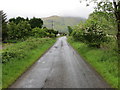
Minor road approaching Camaghael
Looking south-westward.
Image: © Peter Wood
Taken: 26 May 2019
0.20 miles