IMAGES TAKEN NEAR TO
Camaghael, FORT WILLIAM, PH33 7ND
Introduction
This page details the photographs taken nearby to Camaghael, PH33 7ND by members of the Geograph project.
The Geograph project started in 2005 with the aim of publishing, organising and preserving representative images for every square kilometre of Great Britain, Ireland and the Isle of Man.

There are currently over 7.5m images from over14,400 individuals and you can help contribute to the project by visiting https://www.geograph.org.uk
Image Map
Images are licensed for reuse under creativecommons.org/licenses/by-sa/2.0
Notes
- Clicking on the map will re-center to the selected point.
- The higher the marker number, the further away the image location is from the centre of the postcode.
Image Listing (30 Images Found)
Images are licensed for reuse under creativecommons.org/licenses/by-sa/2.0
Image
Details
Distance
3
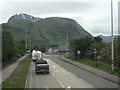
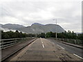
A830 approaching Fort William
This view, taken from the upper deck of a double-deck bus, is of the A830 road approaching Fort William.
Britain's highest mountain, Ben Nevis, looms in the background.
Image: © Malc McDonald
Taken: 25 Jun 2015
0.07 miles

5
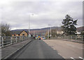
Victoria Bridge
Cars on the bridge spanning the River Lochy.
Image: © Peter Bond
Taken: 4 Nov 2007
0.09 miles
6
Crossing the River Lochy on the A830
Ben Nevis on the far horizon
Image: © Eirian Evans
Taken: 15 Sep 2020
0.10 miles
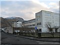
7
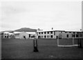
Lochaber High School Hostel
A hostel for pupils from the West Highlands, the Uists, Barra, Skye and the Small Isles who lived too far from school to travel every day. It was opened in 1961. This was taken around April 1963. To the left are the main Lochaber High School buildings. At this time it was a hostel for boys only although I believe it was subsequently extended to provide accommodation for girls as well.
Image: © Chris Anderson
Taken: Unknown
0.10 miles
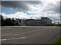
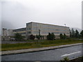
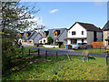
9
New houses, Lochyside
The road is now a dead end after realignment of the junction of Killmallie Road and the A830.
Image: © Richard Webb
Taken: 3 Jun 2017
0.11 miles
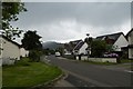
10
Detached houses west from Victoria Bridge
The houses are at a location which appears to be named Lochyside, or Taobh Lochaidh in Gaelic. Victoria Bridge carries the A830 across the River Lochy and is alternatively known as Lochy Bridge.
Image: © Trevor Littlewood
Taken: 25 Apr 2017
0.12 miles