IMAGES TAKEN NEAR TO
Mackay Crescent, FORT WILLIAM, PH33 7JB
Introduction
This page details the photographs taken nearby to Mackay Crescent, PH33 7JB by members of the Geograph project.
The Geograph project started in 2005 with the aim of publishing, organising and preserving representative images for every square kilometre of Great Britain, Ireland and the Isle of Man.

There are currently over 7.5m images from over14,400 individuals and you can help contribute to the project by visiting https://www.geograph.org.uk
Image Map
Images are licensed for reuse under creativecommons.org/licenses/by-sa/2.0
Notes
- Clicking on the map will re-center to the selected point.
- The higher the marker number, the further away the image location is from the centre of the postcode.
Image Listing (130 Images Found)
Images are licensed for reuse under creativecommons.org/licenses/by-sa/2.0
Image
Details
Distance
1
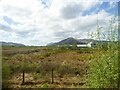
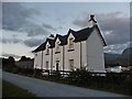
Heathland at Caol
The building is Inverness Gaelic Primary School.
Image: © Rod Allday
Taken: 25 Apr 2019
0.08 miles
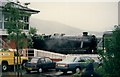
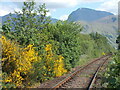
3
Banavie Station
SE view, towards Fort William, on line from Mallaig. Ben Nevis (4,408 ft.) prominent 5 miles ahead.
Image: © Ben Brooksbank
Taken: 30 Sep 1961
0.10 miles
4
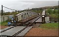
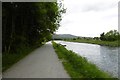
Banavie railway swing bridge, from the Caledonian Canal towpath
Image: © David Long
Taken: 30 Apr 2009
0.12 miles
7
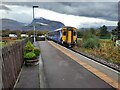
Train approaching Banavie station
The train to Mallaig pulling into Banavie Station, with the top of Ben Nevis shrouded in cloud in the distance.
Image: © Clive Nicholson
Taken: 20 Oct 2020
0.12 miles
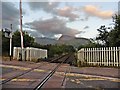
8
Crossing the railway line at Banavie
A very familiar mountain profile in the background.
Image: © Peter S
Taken: 3 Jun 2023
0.12 miles
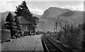
10
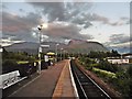
Banavie railway station
An earlier view: Image
Image: © Roger Cornfoot
Taken: 21 Jun 2018
0.12 miles