IMAGES TAKEN NEAR TO
Fern Court, FORT WILLIAM, PH33 7EX
Introduction
This page details the photographs taken nearby to Fern Court, PH33 7EX by members of the Geograph project.
The Geograph project started in 2005 with the aim of publishing, organising and preserving representative images for every square kilometre of Great Britain, Ireland and the Isle of Man.

There are currently over 7.5m images from over14,400 individuals and you can help contribute to the project by visiting https://www.geograph.org.uk
Image Map
Images are licensed for reuse under creativecommons.org/licenses/by-sa/2.0
Notes
- Clicking on the map will re-center to the selected point.
- The higher the marker number, the further away the image location is from the centre of the postcode.
Image Listing (8 Images Found)
Images are licensed for reuse under creativecommons.org/licenses/by-sa/2.0
Image
Details
Distance
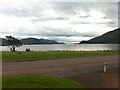
2
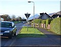
Sign for the Great Glen Way and Fort William
Having left the shore of Loch Linnhe, a stretch of road walking follows next but with the familiar profile of Ben Nevis ahead. The route leaves the road at the Soldier's Bridge.
Image: © Peter S
Taken: 3 Jun 2023
0.20 miles
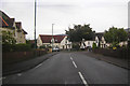
4
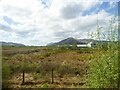
Heathland at Caol
The building is Inverness Gaelic Primary School.
Image: © Rod Allday
Taken: 25 Apr 2019
0.21 miles
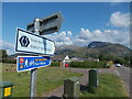
6
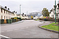
Glenmallie Road, Caol
The Great Glen Way follows this road around to the shore of Loch Linnhe to reach the Caledonian Canal at Corpach.
Image: © Jim Barton
Taken: 15 Nov 2014
0.23 miles
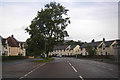
7
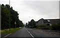
Killmallie Road, Caol
Where it runs alongside the Caledonian Canal.
Image: © Peter Bond
Taken: 10 Oct 2015
0.25 miles