IMAGES TAKEN NEAR TO
Gulvain Crescent, FORT WILLIAM, PH33 7BE
Introduction
This page details the photographs taken nearby to Gulvain Crescent, PH33 7BE by members of the Geograph project.
The Geograph project started in 2005 with the aim of publishing, organising and preserving representative images for every square kilometre of Great Britain, Ireland and the Isle of Man.

There are currently over 7.5m images from over14,400 individuals and you can help contribute to the project by visiting https://www.geograph.org.uk
Image Map
Images are licensed for reuse under creativecommons.org/licenses/by-sa/2.0
Notes
- Clicking on the map will re-center to the selected point.
- The higher the marker number, the further away the image location is from the centre of the postcode.
Image Listing (23 Images Found)
Images are licensed for reuse under creativecommons.org/licenses/by-sa/2.0
Image
Details
Distance
1
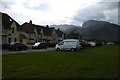
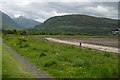
Erracht Drive, Caol
Carn Mòr Dearg and Ben Nevis in the background.
Image: © Richard Webb
Taken: 3 Jun 2017
0.03 miles
2
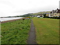
Shoreline pathway at Caol
Looking north-westward.
Image: © Peter Wood
Taken: 26 May 2019
0.05 miles
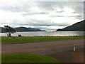
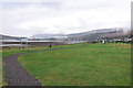
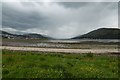
5
Beach, Caol
View up Glen Nevis towards Sgùrr a' Mhaim.
Image: © Richard Webb
Taken: 3 Jun 2017
0.08 miles
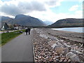
7
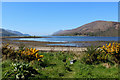
Loch Linnhe from Caol
The head of the sea loch as seen from the Great Glen Way National Trail
Image: © Chris Heaton
Taken: 3 May 2017
0.10 miles
8
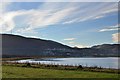
Fort William from Caol
Looking across Loch Linnhe to the town and Cow Hill above.
Image: © Jim Barton
Taken: 15 Nov 2014
0.11 miles
9
Beach, Caol
View down Loch Linnhe into a vigorous shower.
Image: © Richard Webb
Taken: 3 Jun 2017
0.12 miles
10
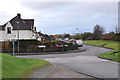
Junction of Erracht Terrace and Glenmallie Road, Caol
Image: © Steven Brown
Taken: 5 Nov 2010
0.12 miles