IMAGES TAKEN NEAR TO
FORT WILLIAM, PH33 7AW
Introduction
This page details the photographs taken nearby to PH33 7AW by members of the Geograph project.
The Geograph project started in 2005 with the aim of publishing, organising and preserving representative images for every square kilometre of Great Britain, Ireland and the Isle of Man.

There are currently over 7.5m images from over14,400 individuals and you can help contribute to the project by visiting https://www.geograph.org.uk
Image Map
Images are licensed for reuse under creativecommons.org/licenses/by-sa/2.0
Notes
- Clicking on the map will re-center to the selected point.
- The higher the marker number, the further away the image location is from the centre of the postcode.
Image Listing (9 Images Found)
Images are licensed for reuse under creativecommons.org/licenses/by-sa/2.0
Image
Details
Distance
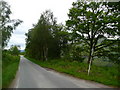
2
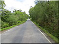
Tree-lined road (A861) at South Garvan
Looking eastward.
Image: © Peter Wood
Taken: 27 May 2019
0.06 miles
3
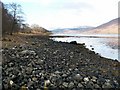
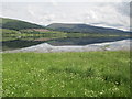
Loch Eil shore line by South Garvan
Typical Loch Eil shore line. This shot taken looking west along the south shore east of South Garvan.
Image: © Jim Bain
Taken: 19 Feb 2006
0.13 miles
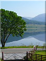
8
Loch Eil foreshore near Rubha Caladh na Creige
Image: © Nigel Brown
Taken: 13 Jun 2015
0.19 miles
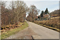
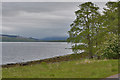
9
The south Loch Eil road at Garvan
If the ferry at Corran is closed for the night, this is the long way round to Ardnamurchan.
Image: © Gordon Brown
Taken: 5 Jun 2011
0.20 miles