IMAGES TAKEN NEAR TO
Ardgour, FORT WILLIAM, PH33 7AB
Introduction
This page details the photographs taken nearby to PH33 7AB by members of the Geograph project.
The Geograph project started in 2005 with the aim of publishing, organising and preserving representative images for every square kilometre of Great Britain, Ireland and the Isle of Man.

There are currently over 7.5m images from over14,400 individuals and you can help contribute to the project by visiting https://www.geograph.org.uk
Image Map
Images are licensed for reuse under creativecommons.org/licenses/by-sa/2.0
Notes
- Clicking on the map will re-center to the selected point.
- The higher the marker number, the further away the image location is from the centre of the postcode.
Image Listing (20 Images Found)
Images are licensed for reuse under creativecommons.org/licenses/by-sa/2.0
Image
Details
Distance
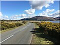
1
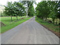
Minor road to Clovullin
Looking north-eastward.
Image: © Peter Wood
Taken: 28 May 2019
0.06 miles
2
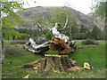
Felled Beech at Clovullin
Next years firewood - beech burns well!
Image: © M J Richardson
Taken: 17 May 2013
0.08 miles
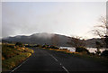
3

Not burnt yet
The beech that was cut down a year earlier. Image
Image: © Richard Webb
Taken: 17 Apr 2014
0.09 miles
4

Woodland, Clovullin
This bit of the new crop will be broadleaved.
Image: © Richard Webb
Taken: 17 Apr 2014
0.11 miles
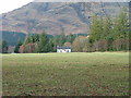
6
Woodend at Clovullin
Apparently unoccupied, under the slopes of Meall Breac.
Image: © M J Richardson
Taken: 17 May 2013
0.12 miles
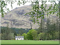
7
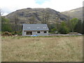
New house at Clovullin
With Meall Breac behind.
Image: © M J Richardson
Taken: 17 May 2013
0.12 miles
9
Deserted crofthouse
On the Ardgour Estate.
Image: © Dave Fergusson
Taken: 7 Feb 2010
0.13 miles
10

Drochaid Mhic Neil
Bridge on the road through Clovullin.
Image: © Richard Webb
Taken: 17 Apr 2014
0.13 miles