IMAGES TAKEN NEAR TO
Carrs Corner Industrial Estate, FORT WILLIAM, PH33 6TL
Introduction
This page details the photographs taken nearby to Carrs Corner Industrial Estate, PH33 6TL by members of the Geograph project.
The Geograph project started in 2005 with the aim of publishing, organising and preserving representative images for every square kilometre of Great Britain, Ireland and the Isle of Man.

There are currently over 7.5m images from over14,400 individuals and you can help contribute to the project by visiting https://www.geograph.org.uk
Image Map
Images are licensed for reuse under creativecommons.org/licenses/by-sa/2.0
Notes
- Clicking on the map will re-center to the selected point.
- The higher the marker number, the further away the image location is from the centre of the postcode.
Image Listing (26 Images Found)
Images are licensed for reuse under creativecommons.org/licenses/by-sa/2.0
Image
Details
Distance
2
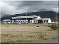
Police Station, Fort William
A new facility on The Blar, between Lochy Bridge and Banavie.
Image: © M J Richardson
Taken: 15 Apr 2017
0.06 miles

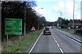
4
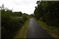
Fort William to Torlundy cycle path
The path was busy despite the rain as many were using it to get to the Downhill World Cup event at Aonach Mòr.
Image: © Richard Webb
Taken: 3 Jun 2017
0.09 miles
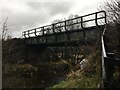
5

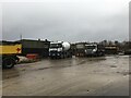
Helicopter landing site, Carr's Corner
An area of land at Carr's Corner, off the A82. This was previously a contractor's yard, but was largely disused for a number of years.
In recent years, this has been used as a landing site for search and rescue helicopters. The green container is a fuel tank.
Image: © Craig Wallace
Taken: 5 Jun 2017
0.11 miles
6
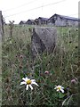
Old Milestone by the A82, northeast of Victoria Bridge, Kilmallie parish
Highland granite by the A82, in parish of Kilmallie (Lochaber District), North of junction with the A830, Victoria Bridge, South of entrance to Highways Depot.
Possibly re-located from bend further North where road appears to have been widened.
Possible Inscription once read:-
: (Spean Bridge / 7) : : (Fort William / 2½) :
Surveyed
Milestone Society National ID: HI_FWFA02
Image: © Milestone Society
Taken: Unknown
0.15 miles

10
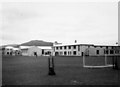
Lochaber High School Hostel
A hostel for pupils from the West Highlands, the Uists, Barra, Skye and the Small Isles who lived too far from school to travel every day. It was opened in 1961. This was taken around April 1963. To the left are the main Lochaber High School buildings. At this time it was a hostel for boys only although I believe it was subsequently extended to provide accommodation for girls as well.
Image: © Chris Anderson
Taken: Unknown
0.20 miles