IMAGES TAKEN NEAR TO
FORT WILLIAM, PH33 6SL
Introduction
This page details the photographs taken nearby to PH33 6SL by members of the Geograph project.
The Geograph project started in 2005 with the aim of publishing, organising and preserving representative images for every square kilometre of Great Britain, Ireland and the Isle of Man.

There are currently over 7.5m images from over14,400 individuals and you can help contribute to the project by visiting https://www.geograph.org.uk
Image Map
Images are licensed for reuse under creativecommons.org/licenses/by-sa/2.0
Notes
- Clicking on the map will re-center to the selected point.
- The higher the marker number, the further away the image location is from the centre of the postcode.
Image Listing (7 Images Found)
Images are licensed for reuse under creativecommons.org/licenses/by-sa/2.0
Image
Details
Distance
1
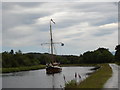
Norwegian sailing ship on Caledonian Canal
Approaching Neptunes staircase to the NE of Banavie
Image: © paul birrell
Taken: 29 Jun 2005
0.08 miles
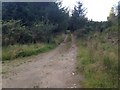
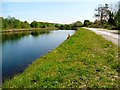
3
Route of Great Glen Way alongside Caledonian Canal
The Great Glen Way uses the pale, grit-surfaced road. The route here is heading south-west, approaching the series of locks known as Neptune's Staircase.
Image: © Trevor Littlewood
Taken: 24 Apr 2017
0.21 miles
4
Tunnel under canal
This gate, on the southern side of the Caledonian Canal, can be used to access the tunnels which run underneath the canal not far from Banavie and allow walkers to pass from one side of the canal to the other https://www.geograph.org.uk/photo/7350352
Image: © Bill Kasman
Taken: 26 Nov 2022
0.22 miles
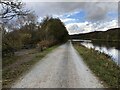
5
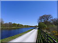
The Great Glen Way following the Caledonian Canal north-east from Banavie
Image: © Tim Heaton
Taken: 3 May 2017
0.22 miles
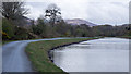
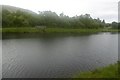
6
A quiet moment on the Caledonian Canal
Completed in 1847 as a 60-mile canal link from Inverness to Fort William to provide a safe route for naval ships during the Napoleonic wars.
Image: © Gordon Brown
Taken: 24 May 2012
0.23 miles
7
Caledonian Canal
There is a bridge on the opposite bank, it is used by a path. On the near bank there is a road.
Image: © Richard Webb
Taken: 4 Jun 2017
0.24 miles