IMAGES TAKEN NEAR TO
Achintore Road, FORT WILLIAM, PH33 6RN
Introduction
This page details the photographs taken nearby to Achintore Road, PH33 6RN by members of the Geograph project.
The Geograph project started in 2005 with the aim of publishing, organising and preserving representative images for every square kilometre of Great Britain, Ireland and the Isle of Man.

There are currently over 7.5m images from over14,400 individuals and you can help contribute to the project by visiting https://www.geograph.org.uk
Image Map
Images are licensed for reuse under creativecommons.org/licenses/by-sa/2.0
Notes
- Clicking on the map will re-center to the selected point.
- The higher the marker number, the further away the image location is from the centre of the postcode.
Image Listing (16 Images Found)
Images are licensed for reuse under creativecommons.org/licenses/by-sa/2.0
Image
Details
Distance
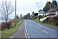
5
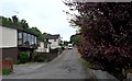
Quiet residential cul-de-sac in Fort William
Image: © Alan Reid
Taken: 11 Jun 2012
0.08 miles
6
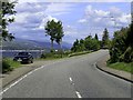
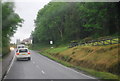
Achintore Road heading to Fort William
Image: © Steve Daniels
Taken: 8 Jul 2019
0.10 miles

9
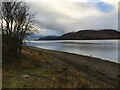
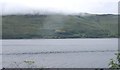
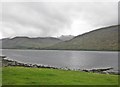
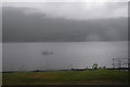
Shoreline of Loch Linnhe near Fort William
Image: © Steven Brown
Taken: 9 Jan 2022
0.14 miles