IMAGES TAKEN NEAR TO
Maryburgh Court, FORT WILLIAM, PH33 6QP
Introduction
This page details the photographs taken nearby to Maryburgh Court, PH33 6QP by members of the Geograph project.
The Geograph project started in 2005 with the aim of publishing, organising and preserving representative images for every square kilometre of Great Britain, Ireland and the Isle of Man.

There are currently over 7.5m images from over14,400 individuals and you can help contribute to the project by visiting https://www.geograph.org.uk
Image Map
Images are licensed for reuse under creativecommons.org/licenses/by-sa/2.0
Notes
- Clicking on the map will re-center to the selected point.
- The higher the marker number, the further away the image location is from the centre of the postcode.
Image Listing (323 Images Found)
Images are licensed for reuse under creativecommons.org/licenses/by-sa/2.0
Image
Details
Distance
1
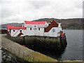
Crannog Restaurant, Fort William
It is located at the town pier - more at http://www.visit-fortwilliam.co.uk/listings_188_Crannog-Restaurant.html
Image: © Kenneth Allen
Taken: 16 Apr 2011
0.01 miles
2
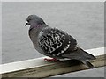
Pigeon, Fort William
A tame bird, giving me the eye sideways.
Image: © Kenneth Allen
Taken: 16 Apr 2011
0.01 miles
3
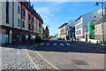
Fort William High Street
Although most of Fort William High Street is pedestrianised, a short stretch at the south-eastern end remains open to traffic.
Image: © Malc McDonald
Taken: 25 Jun 2015
0.01 miles
4
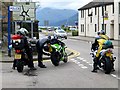
Bikers, Fort William
Having a quick look at the bike
Image: © Kenneth Allen
Taken: 23 Jul 2013
0.02 miles
5
Fort William High Street
Looking south-west towards the West End Roundabout.
Image: © Bill Kasman
Taken: 7 Sep 2019
0.02 miles
6
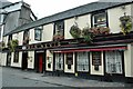
Ben Nevis Pub, High Street, Fort William, Scotland
Image: © Ann Causer
Taken: Unknown
0.02 miles
7
A82 Road, Fort William
Looking north-east
Image: © Kenneth Allen
Taken: 23 Jul 2013
0.02 miles
8
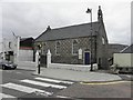
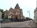
Church of Scotland, Fort William
It is located near the west end of High Street
Image: © Kenneth Allen
Taken: 16 Apr 2011
0.02 miles
9
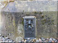
Ordnance Survey Flush Bracket G1172
This can be found on the wall of Fort William Sheriff Office. The benchmarks' recorded height is 8.172 metres above sea level.
For more detail see : https://www.bench-marks.org.uk/bm580
Image: © Peter Wood
Taken: 26 May 2019
0.02 miles
10
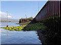
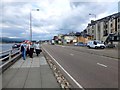
Loch Side, Fort William
A view along the "loch wall" below the main A82 road at Fort William. taken from the landing stage at the pier.
Image: © David Dixon
Taken: 25 May 2017
0.02 miles