IMAGES TAKEN NEAR TO
Grant Place, FORT WILLIAM, PH33 6QE
Introduction
This page details the photographs taken nearby to Grant Place, PH33 6QE by members of the Geograph project.
The Geograph project started in 2005 with the aim of publishing, organising and preserving representative images for every square kilometre of Great Britain, Ireland and the Isle of Man.

There are currently over 7.5m images from over14,400 individuals and you can help contribute to the project by visiting https://www.geograph.org.uk
Image Map
Images are licensed for reuse under creativecommons.org/licenses/by-sa/2.0
Notes
- Clicking on the map will re-center to the selected point.
- The higher the marker number, the further away the image location is from the centre of the postcode.
Image Listing (39 Images Found)
Images are licensed for reuse under creativecommons.org/licenses/by-sa/2.0
Image
Details
Distance
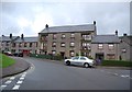
1
Carn Dearg Road, Fort William
Housing estate with a mountainous backdrop.
Image: © Stephen McKay
Taken: 25 Mar 2014
0.11 miles
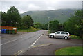
3
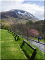
Wooden barriers at edge of grass
The barriers and grassed area are adjacent to car parking at a residential area of Fort William. The mountain beyond might be thought to be Ben Nevis lying as it does to the east of the town but it is in fact Meall an t-Suidhe, at 711m. little more than half the height of 'The Ben'. The road below with two backpackers leads to Achintee, the starting point for the ascent to Ben Nevis by its most frequented route.
Image: © Trevor Littlewood
Taken: 25 Apr 2017
0.12 miles
5
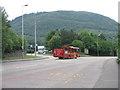
Open-back bus at Fort William
Maybe lost or just relocating - it says 'City sightseeing Oban'. The wooded hill beyond is Cow Hill.
Image: © M J Richardson
Taken: 7 Jun 2016
0.13 miles
6
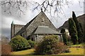
St Mary's Catholic Church
St Mary's church Fort William.
Image: © edward mcmaihin
Taken: 8 Apr 2010
0.13 miles
9
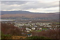
Claggan from Cow Hill
Houses on the N side of Fort William seen from the lower slopes of Cow Hill, with Loch Linnhe and the River Lochy beyond.
Image: © Jim Barton
Taken: 19 Nov 2011
0.14 miles