IMAGES TAKEN NEAR TO
Melantee, FORT WILLIAM, PH33 6PY
Introduction
This page details the photographs taken nearby to Melantee, PH33 6PY by members of the Geograph project.
The Geograph project started in 2005 with the aim of publishing, organising and preserving representative images for every square kilometre of Great Britain, Ireland and the Isle of Man.

There are currently over 7.5m images from over14,400 individuals and you can help contribute to the project by visiting https://www.geograph.org.uk
Image Map
Images are licensed for reuse under creativecommons.org/licenses/by-sa/2.0
Notes
- Clicking on the map will re-center to the selected point.
- The higher the marker number, the further away the image location is from the centre of the postcode.
Image Listing (66 Images Found)
Images are licensed for reuse under creativecommons.org/licenses/by-sa/2.0
Image
Details
Distance
1
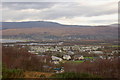
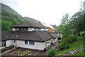
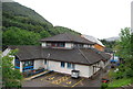
Claggan from Cow Hill
Houses on the N side of Fort William seen from the lower slopes of Cow Hill, with Loch Linnhe and the River Lochy beyond.
Image: © Jim Barton
Taken: 19 Nov 2011
0.06 miles
2
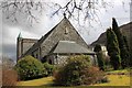
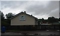
St Mary's Catholic Church
St Mary's church Fort William.
Image: © edward mcmaihin
Taken: 8 Apr 2010
0.07 miles
6
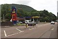
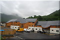
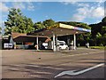
Petrol station, North Road, Fort William
A fuel filling station on North Road, operating under the Gleaner brand.
Image: © Graham Robson
Taken: 17 Jun 2018
0.09 miles