IMAGES TAKEN NEAR TO
Tomnafaidhir, FORT WILLIAM, PH33 6PU
Introduction
This page details the photographs taken nearby to Tomnafaidhir, PH33 6PU by members of the Geograph project.
The Geograph project started in 2005 with the aim of publishing, organising and preserving representative images for every square kilometre of Great Britain, Ireland and the Isle of Man.

There are currently over 7.5m images from over14,400 individuals and you can help contribute to the project by visiting https://www.geograph.org.uk
Image Map
Images are licensed for reuse under creativecommons.org/licenses/by-sa/2.0
Notes
- Clicking on the map will re-center to the selected point.
- The higher the marker number, the further away the image location is from the centre of the postcode.
Image Listing (95 Images Found)
Images are licensed for reuse under creativecommons.org/licenses/by-sa/2.0
Image
Details
Distance
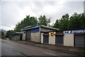
5
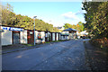
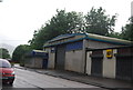
Industrial units in Claggan Road, Fort William
Image: © Dave Fergusson
Taken: 5 Dec 2011
0.05 miles
6
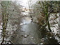
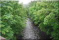
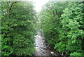
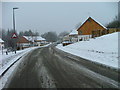
River Nevis
Looking east from the footbridge on Belford Road.
Image: © Dave Fergusson
Taken: 5 Dec 2011
0.05 miles
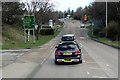
7
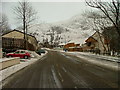
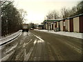
Claggan Road, Fort William
Looking east towards the slopes of Meall an t-Suidhe.
Image: © Dave Fergusson
Taken: 5 Dec 2011
0.06 miles