IMAGES TAKEN NEAR TO
Lochiel Road, FORT WILLIAM, PH33 6NS
Introduction
This page details the photographs taken nearby to Lochiel Road, PH33 6NS by members of the Geograph project.
The Geograph project started in 2005 with the aim of publishing, organising and preserving representative images for every square kilometre of Great Britain, Ireland and the Isle of Man.

There are currently over 7.5m images from over14,400 individuals and you can help contribute to the project by visiting https://www.geograph.org.uk
Image Map
Images are licensed for reuse under creativecommons.org/licenses/by-sa/2.0
Notes
- Clicking on the map will re-center to the selected point.
- The higher the marker number, the further away the image location is from the centre of the postcode.
Image Listing (46 Images Found)
Images are licensed for reuse under creativecommons.org/licenses/by-sa/2.0
Image
Details
Distance
1
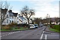
Locheil Road, Inverlochy
Inverlochy was laid out in 1926 as a 'garden city' suburb by the British Aluminium Company to house its workforce for the nearby smelter.
Image: © Jim Barton
Taken: 15 Nov 2014
0.02 miles
2
Waste ground near Inverlochy 1979
Too close to the railway for productive use. Look at that mustard yellow Triumph Toledo - cool car for the time!
Image: © Peter Whatley
Taken: Unknown
0.09 miles
3
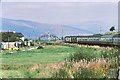
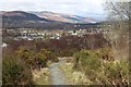
Lines and sidings near Fort William
Sidings off the West Highland Line seen from the footbridge to Inverlochy. In the background is Cow Hill.
Image: © Jim Barton
Taken: 15 Nov 2014
0.09 miles
4
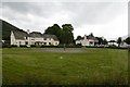
Play area at Inverlochy
In a small housing estate north of the River Nevis.
Image: © M J Richardson
Taken: 15 Apr 2017
0.09 miles
5
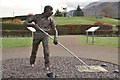
'Breaking the Crust', Inverlochy
A sculpture by David Annand based on a furnaceman working in the aluminium smelter in 1962. The water pipes supplying the plant's hydroelectric generators can be seen in the background framed by the children's swings.
Image: © Jim Barton
Taken: 15 Nov 2014
0.09 miles
6
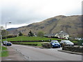
Inverlochy
Suburb built to accommodate aluminium workers.
Image: © Richard Webb
Taken: 3 Jun 2017
0.09 miles
7
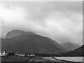
Ben Nevis
From Caol loch shore towards Glen Nevis and "The Ben".
Image: © John Webber
Taken: 10 Sep 2008
0.09 miles
8
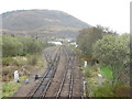
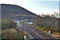
The West Highland Railway at Inverlochy
Looking south towards Fort William, and Cow Hill.
Image: © M J Richardson
Taken: 15 Apr 2017
0.10 miles
9
Inverlochy, Fort William
From the path above Nevis Bridge. The southern approach to the Great Glen is enjoying a blink of sun
Image: © Alan Reid
Taken: 26 Apr 2013
0.11 miles
10
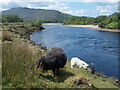
Black sheep, white lamb by the River Nevis
On the Great Glen Way between Fort William and Banavie.
Image: © Peter S
Taken: 3 Jun 2023
0.11 miles