IMAGES TAKEN NEAR TO
Argyll Road, FORT WILLIAM, PH33 6LD
Introduction
This page details the photographs taken nearby to Argyll Road, PH33 6LD by members of the Geograph project.
The Geograph project started in 2005 with the aim of publishing, organising and preserving representative images for every square kilometre of Great Britain, Ireland and the Isle of Man.

There are currently over 7.5m images from over14,400 individuals and you can help contribute to the project by visiting https://www.geograph.org.uk
Image Map
Images are licensed for reuse under creativecommons.org/licenses/by-sa/2.0
Notes
- Clicking on the map will re-center to the selected point.
- The higher the marker number, the further away the image location is from the centre of the postcode.
Image Listing (182 Images Found)
Images are licensed for reuse under creativecommons.org/licenses/by-sa/2.0
Image
Details
Distance
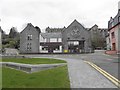
1
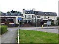
West End Hotel, Fort William
Looking south-east
Image: © Kenneth Allen
Taken: 23 Jul 2013
0.09 miles
2
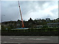
Demolition of old school in Achintore Road
Image: © Dave Fergusson
Taken: 24 Apr 2012
0.11 miles
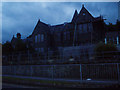
3
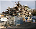
Restoration work, Fort William Primary School
This school was built circa 1876, designed by Alexander Ross. It has been disused for a number of years, and the building was deteriorating.
Work has now started to restore the building, and convert it into council offices and archives. Several of the more modern adjacent school have been demolished.
It is a Category B listed building. http://portal.historicenvironment.scot/designation/LB43374
It is on the Buildings at Risk Register for Scotland. https://buildingsatrisk.org.uk/search/planning_authority/190/map/1/event_id/895966/building_name/fort-william-primary-school-former-achintore-road-fort-william
Image: © Craig Wallace
Taken: 24 Feb 2018
0.11 miles
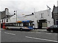
4
Police Station, Fort William
It is located along High Street
Image: © Kenneth Allen
Taken: 16 Apr 2011
0.11 miles
5
Highland and Islands Enterprise, Fort William
It is located at St Mary's House, Gordon Square, off High Street
Image: © Kenneth Allen
Taken: 16 Apr 2011
0.11 miles
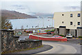
6
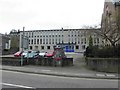
Fort William Primary School
Disused school overlooking Loch Linnhe.
Image: © C A Millar
Taken: Unknown
0.12 miles
7
Lundavra Road, Fort William
The lower end of Lundavra Road where it meets the A82 at a mini-roundabout.
Image: © Jim Barton
Taken: 16 Nov 2019
0.12 miles
8
Scottish Crafts, Fort William
It is located along High Street
Image: © Kenneth Allen
Taken: 16 Apr 2011
0.12 miles
9
Spice Tandoori, Fort William
It is located along High Street.
Image: © Kenneth Allen
Taken: 16 Apr 2011
0.12 miles
10
Hyper Hut / Fired Art, Fort William
They are located along High Street
Image: © Kenneth Allen
Taken: 16 Apr 2011
0.12 miles