IMAGES TAKEN NEAR TO
Glenlochy Road, FORT WILLIAM, PH33 6GX
Introduction
This page details the photographs taken nearby to Glenlochy Road, PH33 6GX by members of the Geograph project.
The Geograph project started in 2005 with the aim of publishing, organising and preserving representative images for every square kilometre of Great Britain, Ireland and the Isle of Man.

There are currently over 7.5m images from over14,400 individuals and you can help contribute to the project by visiting https://www.geograph.org.uk
Image Map
Images are licensed for reuse under creativecommons.org/licenses/by-sa/2.0
Notes
- Clicking on the map will re-center to the selected point.
- The higher the marker number, the further away the image location is from the centre of the postcode.
Image Listing (102 Images Found)
Images are licensed for reuse under creativecommons.org/licenses/by-sa/2.0
Image
Details
Distance

7
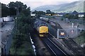
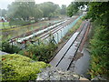
Passing the oil depot
A light locomotive 37423 passes the oil depot south of Mallaig Junction en route to the locomotive shed. Some oil tanks await discharge behind the locomotive and will be collected later.
Image: © roger geach
Taken: 20 Jul 1988
0.05 miles