IMAGES TAKEN NEAR TO
Croft Road, FORT WILLIAM, PH33 6EX
Introduction
This page details the photographs taken nearby to Croft Road, PH33 6EX by members of the Geograph project.
The Geograph project started in 2005 with the aim of publishing, organising and preserving representative images for every square kilometre of Great Britain, Ireland and the Isle of Man.

There are currently over 7.5m images from over14,400 individuals and you can help contribute to the project by visiting https://www.geograph.org.uk
Image Map (Loading...)


Getting Data...Please wait
Leaflet Map data © OpenStreetMap
Images are licensed for reuse under creativecommons.org/licenses/by-sa/2.0
Notes
- Clicking on the map will re-center to the selected point.
- The higher the marker number, the further away the image location is from the centre of the postcode.
Image Listing (140 Images Found)
Images are licensed for reuse under creativecommons.org/licenses/by-sa/2.0
Image
Details
Distance
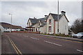
2
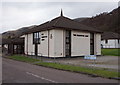
Salvation Army Church
Glen Nevis Place, Fort William.
Image: © Ian S
Taken: 1 Dec 2016
0.03 miles
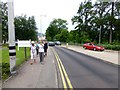
4
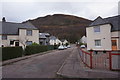
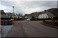
Junction of Croft Road and Glen Nevis Place
Taken from the 'Sugar Loaf' a popular play area for the local children. The A82 Fort William to Inverness road is in the background.
Image: © David Mitchell
Taken: 26 May 2003
0.05 miles