IMAGES TAKEN NEAR TO
AUCHTERARDER, PH3 1LH
Introduction
This page details the photographs taken nearby to PH3 1LH by members of the Geograph project.
The Geograph project started in 2005 with the aim of publishing, organising and preserving representative images for every square kilometre of Great Britain, Ireland and the Isle of Man.

There are currently over 7.5m images from over14,400 individuals and you can help contribute to the project by visiting https://www.geograph.org.uk
Image Map
Images are licensed for reuse under creativecommons.org/licenses/by-sa/2.0
Notes
- Clicking on the map will re-center to the selected point.
- The higher the marker number, the further away the image location is from the centre of the postcode.
Image Listing (3 Images Found)
Images are licensed for reuse under creativecommons.org/licenses/by-sa/2.0
Image
Details
Distance
1
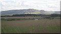
Arable land , Trinity Gask
Looking down to the River Earn from the road.
Image: © Richard Webb
Taken: 16 May 2013
0.08 miles
2
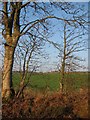
Fields at Trinity Gask
Looking north through roadside trees at Trinity Gask
Image: © Jackie Proven
Taken: 8 Jan 2006
0.12 miles
3
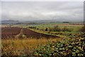
Ploughed field at Trinity Gask
The gap in the Ochil Hills is Glen Devon.
Image: © Alan Reid
Taken: 23 Oct 2017
0.18 miles