IMAGES TAKEN NEAR TO
AUCHTERARDER, PH3 1JX
Introduction
This page details the photographs taken nearby to PH3 1JX by members of the Geograph project.
The Geograph project started in 2005 with the aim of publishing, organising and preserving representative images for every square kilometre of Great Britain, Ireland and the Isle of Man.

There are currently over 7.5m images from over14,400 individuals and you can help contribute to the project by visiting https://www.geograph.org.uk
Image Map
Images are licensed for reuse under creativecommons.org/licenses/by-sa/2.0
Notes
- Clicking on the map will re-center to the selected point.
- The higher the marker number, the further away the image location is from the centre of the postcode.
Image Listing (5 Images Found)
Images are licensed for reuse under creativecommons.org/licenses/by-sa/2.0
Image
Details
Distance
2
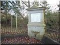
War Memorial, Tullibardine
Unusually this memorial lists those who served as well as those who died.
Image: © paul birrell
Taken: 13 Feb 2007
0.18 miles
3
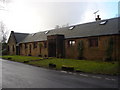
Strathallan Village Hall, Tullibardine
Now a private house
Image: © paul birrell
Taken: 13 Feb 2007
0.22 miles
4
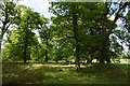
Woodland, Tullibardine
Well scattered oak wood between a couple of roads.
Image: © Richard Webb
Taken: 25 May 2017
0.23 miles
5
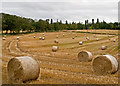
Farmland near Tullibardine
Recently harvested hay bales near Tullibardine still lying in the fields, after a particularly wet summer.
Image: © William Starkey
Taken: 9 Oct 2011
0.24 miles