IMAGES TAKEN NEAR TO
AUCHTERARDER, PH3 1HZ
Introduction
This page details the photographs taken nearby to PH3 1HZ by members of the Geograph project.
The Geograph project started in 2005 with the aim of publishing, organising and preserving representative images for every square kilometre of Great Britain, Ireland and the Isle of Man.

There are currently over 7.5m images from over14,400 individuals and you can help contribute to the project by visiting https://www.geograph.org.uk
Image Map
Images are licensed for reuse under creativecommons.org/licenses/by-sa/2.0
Notes
- Clicking on the map will re-center to the selected point.
- The higher the marker number, the further away the image location is from the centre of the postcode.
Image Listing (4 Images Found)
Images are licensed for reuse under creativecommons.org/licenses/by-sa/2.0
Image
Details
Distance
1
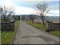
Entrance to where?
The O.S. maps give this place the Gaelic name of 'Fraoch Geal' (White Heather) but that name appears to have been obliterated from the left hand stone pillar below the 'Private' sign, and replaced by 'Farmton' on the other pillar.
Image: © James Allan
Taken: 23 Feb 2009
0.17 miles
3
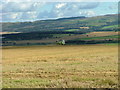
Leaving it until last harvest
With the 07 summer, this crop may still have green in it at harvest.
Image: © James Bisset
Taken: 13 Aug 2007
0.20 miles
4
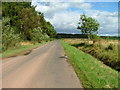
Minor road at Gask
Looking east from near Borestone Cottage.
Image: © Dave Fergusson
Taken: 5 Sep 2011
0.20 miles