IMAGES TAKEN NEAR TO
AUCHTERARDER, PH3 1HX
Introduction
This page details the photographs taken nearby to PH3 1HX by members of the Geograph project.
The Geograph project started in 2005 with the aim of publishing, organising and preserving representative images for every square kilometre of Great Britain, Ireland and the Isle of Man.

There are currently over 7.5m images from over14,400 individuals and you can help contribute to the project by visiting https://www.geograph.org.uk
Image Map
Images are licensed for reuse under creativecommons.org/licenses/by-sa/2.0
Notes
- Clicking on the map will re-center to the selected point.
- The higher the marker number, the further away the image location is from the centre of the postcode.
Image Listing (6 Images Found)
Images are licensed for reuse under creativecommons.org/licenses/by-sa/2.0
Image
Details
Distance
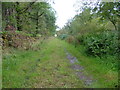
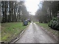
1
Roman road, Gask ridge
The Gask ridge road in woodland.
Image: © Richard Webb
Taken: 16 May 2013
0.09 miles
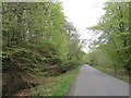
2
Woodland, Gask
Woodland beside the Roman road along the Gask ridge.
Image: © Richard Webb
Taken: 16 May 2013
0.13 miles
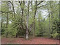
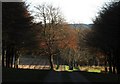
3
Autumn leaves and spring mud
Forest track north of Gask House
Image: © James Allan
Taken: 23 Feb 2009
0.13 miles
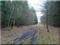
5
Track through woodland
The track leads from the heavily wooded road near Findo Gask, through fields and mature trees towards Gask House
Image: © Jackie Proven
Taken: 11 Nov 2007
0.20 miles