IMAGES TAKEN NEAR TO
Oak Drive, AUCHTERARDER, PH3 1GN
Introduction
This page details the photographs taken nearby to Oak Drive, PH3 1GN by members of the Geograph project.
The Geograph project started in 2005 with the aim of publishing, organising and preserving representative images for every square kilometre of Great Britain, Ireland and the Isle of Man.

There are currently over 7.5m images from over14,400 individuals and you can help contribute to the project by visiting https://www.geograph.org.uk
Image Map
Images are licensed for reuse under creativecommons.org/licenses/by-sa/2.0
Notes
- Clicking on the map will re-center to the selected point.
- The higher the marker number, the further away the image location is from the centre of the postcode.
Image Listing (20 Images Found)
Images are licensed for reuse under creativecommons.org/licenses/by-sa/2.0
Image
Details
Distance
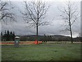
1
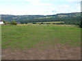
View from Townhead Farm to the Ochil hills
Image: © Ally Kay
Taken: 13 Aug 2005
0.05 miles
2
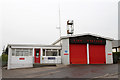
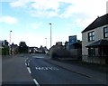
Auchterarder Fire Station
Located on Sydney Crescent.
Image: © Martin Addison
Taken: 5 May 2011
0.09 miles
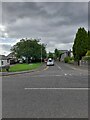
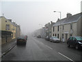
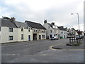
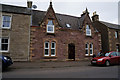
6
Properties on High Street, Auchterarder
Image: © Richard Sutcliffe
Taken: 20 Feb 2017
0.17 miles
10
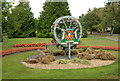
Auchterarder Town Crest
On display in the gardens of St. Margaret's Hospital beside the A824.
Image: © Martin Addison
Taken: 25 Jul 2018
0.18 miles