IMAGES TAKEN NEAR TO
Mennieburn Road, AUCHTERARDER, PH3 1EQ
Introduction
This page details the photographs taken nearby to Mennieburn Road, PH3 1EQ by members of the Geograph project.
The Geograph project started in 2005 with the aim of publishing, organising and preserving representative images for every square kilometre of Great Britain, Ireland and the Isle of Man.

There are currently over 7.5m images from over14,400 individuals and you can help contribute to the project by visiting https://www.geograph.org.uk
Image Map (Loading...)


Getting Data...Please wait
Leaflet Map data © OpenStreetMap
Images are licensed for reuse under creativecommons.org/licenses/by-sa/2.0
Notes
- Clicking on the map will re-center to the selected point.
- The higher the marker number, the further away the image location is from the centre of the postcode.
Image Listing (10 Images Found)
Images are licensed for reuse under creativecommons.org/licenses/by-sa/2.0
Image
Details
Distance
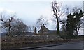
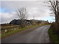
1
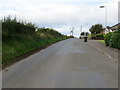
Road leaving Aberuthven and heading for Bailielands
Looking north-westward.
Image: © Peter Wood
Taken: 3 Oct 2017
0.01 miles
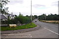
2
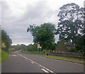
Looking along the A824
Passing the cemetery and St Kattan's Chapel at Aberuthven.
Image: © C Michael Hogan
Taken: 8 Jul 2012
0.11 miles
3
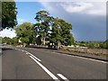
Village of Aberuthven between Auchterarder and Perth
Image: © Elliott Simpson
Taken: 31 Aug 2017
0.11 miles
5
The remains of St. Kattan's Chapel, Aberuthven
Image: © Alpin Stewart
Taken: 25 Feb 2014
0.13 miles
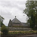
7
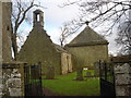
Aberuthven church and cemetery
Ruined chapel and old graveyard in village of Aberuthven between Auchterarder and Perth.
Image: © paul birrell
Taken: 13 Feb 2007
0.13 miles
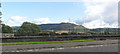
10
Baillielands Farm , Aberuthven, Perthshire
Large stack of silage in black poly bags for winter feed.
Image: © paul birrell
Taken: 13 Feb 2007
0.23 miles