IMAGES TAKEN NEAR TO
Belvidere Place, AUCHTERARDER, PH3 1AS
Introduction
This page details the photographs taken nearby to Belvidere Place, PH3 1AS by members of the Geograph project.
The Geograph project started in 2005 with the aim of publishing, organising and preserving representative images for every square kilometre of Great Britain, Ireland and the Isle of Man.

There are currently over 7.5m images from over14,400 individuals and you can help contribute to the project by visiting https://www.geograph.org.uk
Image Map
Images are licensed for reuse under creativecommons.org/licenses/by-sa/2.0
Notes
- Clicking on the map will re-center to the selected point.
- The higher the marker number, the further away the image location is from the centre of the postcode.
Image Listing (52 Images Found)
Images are licensed for reuse under creativecommons.org/licenses/by-sa/2.0
Image
Details
Distance
2
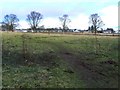
Trees on the common
A muddy footpath across the common land south of Auchterarder.
Image: © James Allan
Taken: 26 Feb 2009
0.14 miles
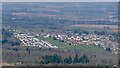
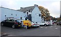
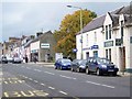
3
Dunlop Park, Auchterarder
A narrow strip of greenspace running southeast off the High Street.
Image: © Richard Sutcliffe
Taken: 20 Feb 2017
0.14 miles
4
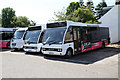
Docherty's Midland Coaches
Providing many of the local bus services during the week, Sunday finds the vehicles resting in Docherty's yard beside Ruthven Street. The nearest vehicles are Optare Solo's whilst the third is a Mercedes-Benz with Sitcar bodywork. Larger vehicles were parked around the yard and in the maintenance shed.
Image: © Martin Addison
Taken: 1 May 2011
0.15 miles
5
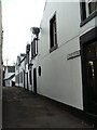
Baker's Wynd
Side street in Auchterarder.
Image: © James Allan
Taken: 26 Feb 2009
0.16 miles
7
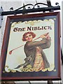
Sign for the Niblick
A niblick is an iron-headed golf club with the face slanted at a greater angle than any other iron except a wedge. The origin of the word is unknown.
Image: © Maigheach-gheal
Taken: 9 Oct 2009
0.17 miles
8
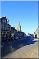
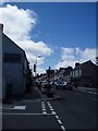
High Street Auchterarder
The High Street viewed looking east
Image: © edward mcmaihin
Taken: 1 May 2011
0.18 miles
9
High Street, Auchterarder
The Royal Burgh of Auchterarder is a situated with the Ochil Hills and Gleneagles to the south and Strathearn to the north. The town is laid out with a long main street giving it the nickname of the Lang Toon.
Image: © Maigheach-gheal
Taken: 9 Oct 2009
0.18 miles