IMAGES TAKEN NEAR TO
ROY BRIDGE, PH31 4AQ
Introduction
This page details the photographs taken nearby to PH31 4AQ by members of the Geograph project.
The Geograph project started in 2005 with the aim of publishing, organising and preserving representative images for every square kilometre of Great Britain, Ireland and the Isle of Man.

There are currently over 7.5m images from over14,400 individuals and you can help contribute to the project by visiting https://www.geograph.org.uk
Image Map
Images are licensed for reuse under creativecommons.org/licenses/by-sa/2.0
Notes
- Clicking on the map will re-center to the selected point.
- The higher the marker number, the further away the image location is from the centre of the postcode.
Image Listing (4 Images Found)
Images are licensed for reuse under creativecommons.org/licenses/by-sa/2.0
Image
Details
Distance
1
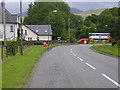
Inverroy Village
The A86 running past the centre of the village, the post office and shop.
Image: © James Denham
Taken: 2 Jul 2008
0.05 miles
2
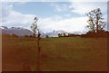
Grey Corries from Insh
Taken on our backpacking trip across Scotland, W to E
Image: © Tom Courtney
Taken: 7 May 1990
0.08 miles
3
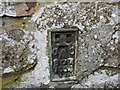
Ordnance Survey Flush Bracket G1054
This can be found on the wall of a building at Foich, Inverroy. The benchmark's recorded height is 85.356 metres above sea level.
For more detail see : https://www.bench-marks.org.uk/bm760
Image: © Peter Wood
Taken: 22 Sep 2019
0.23 miles
4
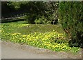
Winter Aconites
On campsite at Roybridge
Image: © Les Harvey
Taken: 18 Apr 2008
0.24 miles