IMAGES TAKEN NEAR TO
Yellowhill Road, PERTH, PH2 9RY
Introduction
This page details the photographs taken nearby to Yellowhill Road, PH2 9RY by members of the Geograph project.
The Geograph project started in 2005 with the aim of publishing, organising and preserving representative images for every square kilometre of Great Britain, Ireland and the Isle of Man.

There are currently over 7.5m images from over14,400 individuals and you can help contribute to the project by visiting https://www.geograph.org.uk
Image Map
Images are licensed for reuse under creativecommons.org/licenses/by-sa/2.0
Notes
- Clicking on the map will re-center to the selected point.
- The higher the marker number, the further away the image location is from the centre of the postcode.
Image Listing (4 Images Found)
Images are licensed for reuse under creativecommons.org/licenses/by-sa/2.0
Image
Details
Distance
1
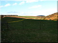
Carmor
Taken from the B996 near Duncrievie, over the M90 to the farm of Carmor. Human bones, swords, beads are reported to have been found when quarrying at Tophead, a steep hill on the SW side of Carmore.
Image: © Lisa Jarvis
Taken: 13 Mar 2007
0.02 miles
2
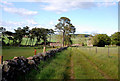
Track to Carmore
Sad to see the ruins of the farm which by its size and the extensive outbuildings must have been a big and busy farm at one time.
Image: © Glen Breaden
Taken: 31 May 2011
0.05 miles
3
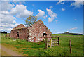
The Cottar's Cottage
Attached to the now deserted farm of Carmore one of the ruinous cottages most likely inhabited by a former farmworker. To the right is West Lomond Hill.
Image: © Glen Breaden
Taken: 31 May 2011
0.07 miles
4
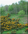
Whins and woodland
Beside the M90 near Carmore.
Image: © JThomas
Taken: 10 May 2014
0.22 miles