IMAGES TAKEN NEAR TO
Glenfarg, PERTH, PH2 9QW
Introduction
This page details the photographs taken nearby to PH2 9QW by members of the Geograph project.
The Geograph project started in 2005 with the aim of publishing, organising and preserving representative images for every square kilometre of Great Britain, Ireland and the Isle of Man.

There are currently over 7.5m images from over14,400 individuals and you can help contribute to the project by visiting https://www.geograph.org.uk
Image Map
Images are licensed for reuse under creativecommons.org/licenses/by-sa/2.0
Notes
- Clicking on the map will re-center to the selected point.
- The higher the marker number, the further away the image location is from the centre of the postcode.
Image Listing (4 Images Found)
Images are licensed for reuse under creativecommons.org/licenses/by-sa/2.0
Image
Details
Distance
1
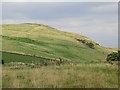
Arlick Hill
Quarry remains on Arlick Hill.
Image: © Richard Webb
Taken: 1 Oct 2013
0.12 miles
4

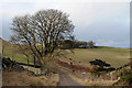
Arlick Hill
The summit area of Arlick Hill, and on the skyline, hills beyond Perth. This is one of two Arlick Hills situated within 10km of each other.
Image: © William Starkey
Taken: 27 Nov 2011
0.21 miles