IMAGES TAKEN NEAR TO
Glenfarg, PERTH, PH2 9QD
Introduction
This page details the photographs taken nearby to PH2 9QD by members of the Geograph project.
The Geograph project started in 2005 with the aim of publishing, organising and preserving representative images for every square kilometre of Great Britain, Ireland and the Isle of Man.

There are currently over 7.5m images from over14,400 individuals and you can help contribute to the project by visiting https://www.geograph.org.uk
Image Map
Images are licensed for reuse under creativecommons.org/licenses/by-sa/2.0
Notes
- Clicking on the map will re-center to the selected point.
- The higher the marker number, the further away the image location is from the centre of the postcode.
Image Listing (8 Images Found)
Images are licensed for reuse under creativecommons.org/licenses/by-sa/2.0
Image
Details
Distance
1
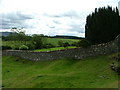
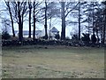
Walled enclosure near Blindwell
The presence of the large Yew tree hints that there may have been a church there at one time.
Image: © Dave Fergusson
Taken: 28 Aug 2010
0.05 miles
2
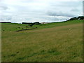
Grazing land at Newton of Balcanquhal
Image: © Dave Fergusson
Taken: 28 Aug 2010
0.08 miles
3
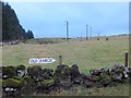
Field near Old Fargie
A good place for a selfie.
Image: © Richard Webb
Taken: 2 Jan 2014
0.18 miles
4
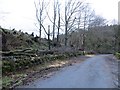
Windthrown beeches
Having lost protection following felling of a plantation behind them, these roadside trees fell to one of the many gales so far this winter.
Image: © Richard Webb
Taken: 2 Jan 2014
0.19 miles
5
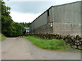
Farm buildings at West Newton of Balcanquhal
Image: © Dave Fergusson
Taken: 28 Aug 2010
0.20 miles
6

Steading Cottage
At West Newton of Balcanquhal.
Image: © Dave Fergusson
Taken: 28 Aug 2010
0.20 miles
7

Straw bales at West Newton of Balcanquhal
With a view towards the Lomond hills.
Image: © Dave Fergusson
Taken: 28 Aug 2010
0.21 miles
8
Farm through the trees
Summerfield farm from the public road
Image: © James Allan
Taken: 18 Jan 2006
0.23 miles