IMAGES TAKEN NEAR TO
Glenfarg, PERTH, PH2 9PE
Introduction
This page details the photographs taken nearby to PH2 9PE by members of the Geograph project.
The Geograph project started in 2005 with the aim of publishing, organising and preserving representative images for every square kilometre of Great Britain, Ireland and the Isle of Man.

There are currently over 7.5m images from over14,400 individuals and you can help contribute to the project by visiting https://www.geograph.org.uk
Image Map (8 Images)


Getting Data...Please wait
Leaflet Map data © OpenStreetMap
Images are licensed for reuse under creativecommons.org/licenses/by-sa/2.0
Notes
- Clicking on the map will re-center to the selected point.
- The higher the marker number, the further away the image location is from the centre of the postcode.
Image Listing (8 Images Found)
Images are licensed for reuse under creativecommons.org/licenses/by-sa/2.0
Image
Details
Distance
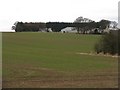
1
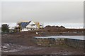
Building site, Drunzie
There is also a plot here which has seen no construction yet.
Image: © Richard Webb
Taken: 2 Jan 2014
0.02 miles
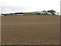
2
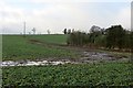
Flood damage
Soil washed out at Colliston during a period of heavy rain.
Image: © Richard Webb
Taken: 2 Jan 2014
0.05 miles
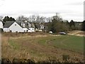
8
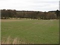
Looking down towards Lossley Burn
A mixed landscape of winter cereals, pasture and wooded hedgerows.
Image: © M J Richardson
Taken: 30 Mar 2009
0.24 miles