IMAGES TAKEN NEAR TO
Glenfarg, PERTH, PH2 9PB
Introduction
This page details the photographs taken nearby to PH2 9PB by members of the Geograph project.
The Geograph project started in 2005 with the aim of publishing, organising and preserving representative images for every square kilometre of Great Britain, Ireland and the Isle of Man.

There are currently over 7.5m images from over14,400 individuals and you can help contribute to the project by visiting https://www.geograph.org.uk
Image Map
Images are licensed for reuse under creativecommons.org/licenses/by-sa/2.0
Notes
- Clicking on the map will re-center to the selected point.
- The higher the marker number, the further away the image location is from the centre of the postcode.
Image Listing (6 Images Found)
Images are licensed for reuse under creativecommons.org/licenses/by-sa/2.0
Image
Details
Distance
2
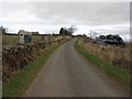
Country road near Duncrievie
A lane from Duncrievie leading to Hilton of Duncrievie.
Image: © M J Richardson
Taken: 30 Mar 2009
0.16 miles
3
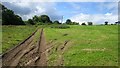
Tractor tracks, Duncrievie
A sunny spell between heavy showers.
Image: © Richard Webb
Taken: 30 Jul 2012
0.16 miles
4
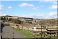
Footpath from Duncrievie to Glenfarg
Glenfarg can be seen in the distance
Image: © Leslie Barrie
Taken: 25 Mar 2015
0.18 miles
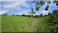
5
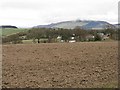
Looking over Duncrievie towards West Lomond
Image: © M J Richardson
Taken: 30 Mar 2009
0.23 miles
6
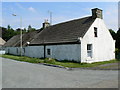
Cottages in Duncrievie
These look as though they really should have thatched roofs, and probably once did.
Image: © James Allan
Taken: 6 Jul 2006
0.24 miles