IMAGES TAKEN NEAR TO
Marindin Park, PERTH, PH2 9NQ
Introduction
This page details the photographs taken nearby to Marindin Park, PH2 9NQ by members of the Geograph project.
The Geograph project started in 2005 with the aim of publishing, organising and preserving representative images for every square kilometre of Great Britain, Ireland and the Isle of Man.

There are currently over 7.5m images from over14,400 individuals and you can help contribute to the project by visiting https://www.geograph.org.uk
Image Map (Loading...)


Getting Data...Please wait
Leaflet Map data © OpenStreetMap
Images are licensed for reuse under creativecommons.org/licenses/by-sa/2.0
Notes
- Clicking on the map will re-center to the selected point.
- The higher the marker number, the further away the image location is from the centre of the postcode.
Image Listing (6 Images Found)
Images are licensed for reuse under creativecommons.org/licenses/by-sa/2.0
Image
Details
Distance
1
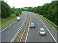
The M90 near Glenfarg
Not much has changed since Image other than the weather.
Image: © Dave Fergusson
Taken: 28 Aug 2010
0.10 miles
2
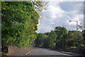
Glenfarg
B996 entering Glenfarg from the north.
Image: © Glen Breaden
Taken: 31 May 2011
0.14 miles
3
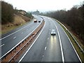
M90 on a wet day
The distant curve is in NO1310 but the bridge from which this was taken is in NO1311
Image: © James Allan
Taken: 18 Jan 2006
0.20 miles
4
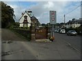
Arngask Library, Glenfarg
This building dates from 1892 and was formerly the Arngask library.
Image: © Euan Nelson
Taken: 11 Oct 2014
0.22 miles
5
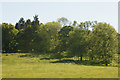
Sheep in a field at Arngask, near Glenfarg
Image: © Mike Pennington
Taken: 3 Jun 2011
0.23 miles
6
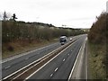
M90 at Glenfarg
Looking north from the footbridge to Arngask.
Image: © M J Richardson
Taken: 30 Mar 2009
0.25 miles