IMAGES TAKEN NEAR TO
Melville Terrace, PERTH, PH2 9NN
Introduction
This page details the photographs taken nearby to Melville Terrace, PH2 9NN by members of the Geograph project.
The Geograph project started in 2005 with the aim of publishing, organising and preserving representative images for every square kilometre of Great Britain, Ireland and the Isle of Man.

There are currently over 7.5m images from over14,400 individuals and you can help contribute to the project by visiting https://www.geograph.org.uk
Image Map
Images are licensed for reuse under creativecommons.org/licenses/by-sa/2.0
Notes
- Clicking on the map will re-center to the selected point.
- The higher the marker number, the further away the image location is from the centre of the postcode.
Image Listing (27 Images Found)
Images are licensed for reuse under creativecommons.org/licenses/by-sa/2.0
Image
Details
Distance
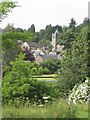
1
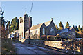
Arngask Church, Glenfarg
Abernethy, and Dron and Arngask Parish Church of Scotland.
Image: © Peter Barr
Taken: 10 Sep 2011
0.11 miles
2
Arngask parish Kirk taken from Glenfarg green
Image: © john bateson
Taken: 2 Jul 2009
0.12 miles
4
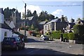
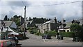
Ladeside and Church Brae, Glenfarg
View from outside the village shop.
Image: © Richard Webb
Taken: 16 Oct 2015
0.14 miles
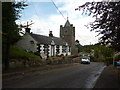
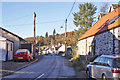
6
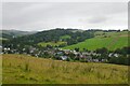
Glenfarg
Quiet since 1981 when the motorway opened, this is a view from outside the post office on Ladeside.
Image: © Richard Webb
Taken: 30 Jul 2012
0.15 miles
7
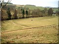
Horses in field
Looking NNE over a field near Glenfarg Riding School. Trees line the banks of the River Farg as it flows East.
Image: © Alfred Fyfe
Taken: 10 Mar 2007
0.15 miles
8
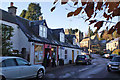
Village shop, Glenfarg
Located in Ladeside, this is now the only shop in the village.
Image: © Richard Dorrell
Taken: 10 Nov 2013
0.15 miles
9
Parish Church, Glenfarg
Located in Church Brae, the church is known as Arngask Church, but if formerly named Abernathy and Dron and Arngask Church of Scotland. The church bears a simple plaque inscribed with the dates 1844 and 1906. The church pictured was built between 1906 and 1907, but it incorporates a part of a former Free Church, built on the same site in 1844.
Image: © Richard Dorrell
Taken: 10 Nov 2013
0.15 miles
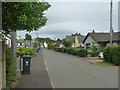
10
Hayfield Road, Glenfarg
A restored and converted barn, 19th century cottages and modern bungalows stand side-by-side in this rural road in Glenfarg village.
Image: © Richard Dorrell
Taken: 10 Nov 2013
0.16 miles