IMAGES TAKEN NEAR TO
Aberargie, PERTH, PH2 9NA
Introduction
This page details the photographs taken nearby to PH2 9NA by members of the Geograph project.
The Geograph project started in 2005 with the aim of publishing, organising and preserving representative images for every square kilometre of Great Britain, Ireland and the Isle of Man.

There are currently over 7.5m images from over14,400 individuals and you can help contribute to the project by visiting https://www.geograph.org.uk
Image Map
Images are licensed for reuse under creativecommons.org/licenses/by-sa/2.0
Notes
- Clicking on the map will re-center to the selected point.
- The higher the marker number, the further away the image location is from the centre of the postcode.
Image Listing (3 Images Found)
Images are licensed for reuse under creativecommons.org/licenses/by-sa/2.0
Image
Details
Distance
2
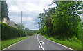
Taking the highway north through a lightly wooded area
Photographer is above the paved surface.
Image: © C Michael Hogan
Taken: 10 Jun 2011
0.23 miles
3
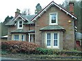
Glenfarg farmhouse
The rather dilapidated triangular plaque to the right of the entrance door once read "Praised be God for all his gifts"
Image: © James Allan
Taken: 18 Jan 2006
0.23 miles