IMAGES TAKEN NEAR TO
Glencairn Place, PERTH, PH2 9JG
Introduction
This page details the photographs taken nearby to Glencairn Place, PH2 9JG by members of the Geograph project.
The Geograph project started in 2005 with the aim of publishing, organising and preserving representative images for every square kilometre of Great Britain, Ireland and the Isle of Man.

There are currently over 7.5m images from over14,400 individuals and you can help contribute to the project by visiting https://www.geograph.org.uk
Image Map
Images are licensed for reuse under creativecommons.org/licenses/by-sa/2.0
Notes
- Clicking on the map will re-center to the selected point.
- The higher the marker number, the further away the image location is from the centre of the postcode.
Image Listing (100 Images Found)
Images are licensed for reuse under creativecommons.org/licenses/by-sa/2.0
Image
Details
Distance
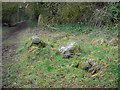
2
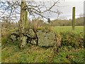
Standing stone
A standing stone at the side of the path beside the Ballo Burn. This may have been part of a stone circle https://canmore.org.uk/site/185835/abernethy-den.
Image: © Richard Sutcliffe
Taken: 2 Mar 2020
0.05 miles
3
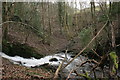
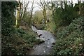
Original route of the Ballo Burn
Looking straight ahead is the original route of the Ballo Burn. A dam Image was constructed (at some time before 1860, as it is shown on an OS map of that date) which diverted the flow of the burn along a new (the current) route a little to the north, through a different channel. The burn can be seen flowing from the left and rejoining the original route.
Image: © Richard Sutcliffe
Taken: 2 Mar 2020
0.06 miles
4
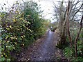
Rough Glen
The relatively smooth footpath through Rough Glen, south of Abernethy.
Image: © James Allan
Taken: 31 Oct 2011
0.07 miles
6
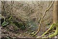
Original route of the Ballo Burn
The photograph is taken from the old dam Image which diverted the flow of the burn along a new (the current) route a little to the north, through a different channel.
Image: © Richard Sutcliffe
Taken: 2 Mar 2020
0.09 miles
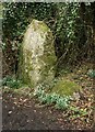
7
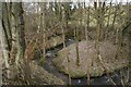
Former mill pond
This was once the mill pond for Ballomill, a few hundred metres downstream. The stone-built dam wall is very obvious, and the 1898 OS map shows a sluice at the right side. The original route of the Ballo Burn Image was to the north northwest (left), but the current route is to the north, through a different channel, marked on some later maps as an aqueduct.
Image: © Richard Sutcliffe
Taken: 2 Mar 2020
0.10 miles
8
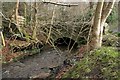
Bridge over the Ballo Burn
A small road bridge giving access to a property off Castlelaw.
Image: © Richard Sutcliffe
Taken: 2 Mar 2020
0.11 miles
9
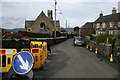
Roadworks on Kirk Wynd, Abernethy
In the distance is the Category B listed former South United Free Church (the Williamson Kirk) http://portal.historicenvironment.scot/designation/LB20919 with its distinctive belfry.
Image: © Richard Sutcliffe
Taken: 2 Mar 2020
0.13 miles
10
Benchmark on wall, Kirkwynd, Abernethy
Spotted whilst walking in the area. An Ordnance Survey benchmark described on database at https://www.bench-marks.org.uk/bm105832. There is very little of this wall remaining so it was satisfying to discover that the benchmark still survives! For close view of benchmark, see https://www.geograph.org.uk/photo/6099861.
Image: © Becky Williamson
Taken: 21 Mar 2019
0.13 miles