IMAGES TAKEN NEAR TO
Bridge Of Earn, PERTH, PH2 9HN
Introduction
This page details the photographs taken nearby to PH2 9HN by members of the Geograph project.
The Geograph project started in 2005 with the aim of publishing, organising and preserving representative images for every square kilometre of Great Britain, Ireland and the Isle of Man.

There are currently over 7.5m images from over14,400 individuals and you can help contribute to the project by visiting https://www.geograph.org.uk
Image Map
Images are licensed for reuse under creativecommons.org/licenses/by-sa/2.0
Notes
- Clicking on the map will re-center to the selected point.
- The higher the marker number, the further away the image location is from the centre of the postcode.
Image Listing (4 Images Found)
Images are licensed for reuse under creativecommons.org/licenses/by-sa/2.0
Image
Details
Distance
1
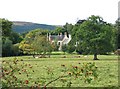
Drummonie House
Picture taken from "Silver Walk" a footpath that runs beside a burn between Drummonie and Ballendrick House
Image: © Keith Proven
Taken: 18 Sep 2005
0.14 miles
2
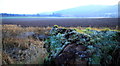
Arable Land at Drummonie
Arable land looking south from Drummonie Cottage
Image: © edward mcmaihin
Taken: 15 Jan 2012
0.16 miles
3
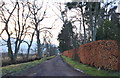
Forgandenny Road
Forgandenny Road at Drummonie.
Image: © edward mcmaihin
Taken: 15 Jan 2012
0.19 miles
4
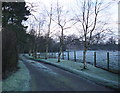
Drummonie Cottage
The start of driveway to Drummonie Cottage.
Image: © edward mcmaihin
Taken: 15 Jan 2012
0.21 miles