IMAGES TAKEN NEAR TO
Sutherland Crescent, PERTH, PH2 9GA
Introduction
This page details the photographs taken nearby to Sutherland Crescent, PH2 9GA by members of the Geograph project.
The Geograph project started in 2005 with the aim of publishing, organising and preserving representative images for every square kilometre of Great Britain, Ireland and the Isle of Man.

There are currently over 7.5m images from over14,400 individuals and you can help contribute to the project by visiting https://www.geograph.org.uk
Image Map
Images are licensed for reuse under creativecommons.org/licenses/by-sa/2.0
Notes
- Clicking on the map will re-center to the selected point.
- The higher the marker number, the further away the image location is from the centre of the postcode.
Image Listing (76 Images Found)
Images are licensed for reuse under creativecommons.org/licenses/by-sa/2.0
Image
Details
Distance
1
Douglas House, Abernethy
On Back Dykes (A913).
Image: © Stanley Howe
Taken: 28 Jun 2016
0.11 miles
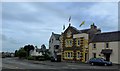
2
The Corn Kist, Abernethy
A 'High Teas' cafe on Back Dykes (A913).
Image: © Stanley Howe
Taken: 28 Jun 2016
0.11 miles
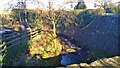
3
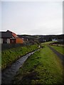
Ballo Burn Hill of Gattaway in the background
Ballo Burn by new housing development.
Image: © A A Lang
Taken: 20 Jan 2008
0.12 miles
5
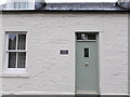
Former Tollhouse
To prove the former use of the cottage just off the A913. TOLL COTTAGE. Number 3 above the door.
Image: © John Riddell
Taken: 18 Oct 2021
0.14 miles
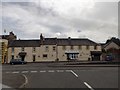
6
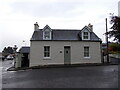
Former Tollhouse
The former tollhouse just off the A913, at 3 Main Street in Abernethy. At one time it was also a shop. It is Category B Listed
Image: © John Riddell
Taken: 18 Oct 2021
0.14 miles
7
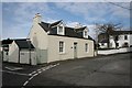
Toll Cottage, Main Street, Abernethy
Category B listed cottage http://portal.historicenvironment.scot/designation/LB20908 on Main Street.
Image: © Richard Sutcliffe
Taken: 2 Mar 2020
0.14 miles
9
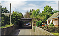
Abernethy station (site/remains)
View northward under the railway, the station having been on the left but was closed 19/9/55: ex-NBR Perth - Bridge of Earn - Newburgh - Ladybank line (also Newburgh - St Fort - (Dundee) until 5/10/64).
Image: © Ben Brooksbank
Taken: 5 Jul 1997
0.15 miles
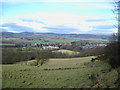
10
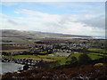
Abernethy from Northside Castle Law
Firth of Tay in far distance.
Image: © A A Lang
Taken: 7 Feb 2009
0.16 miles