IMAGES TAKEN NEAR TO
Forgandenny, PERTH, PH2 9DW
Introduction
This page details the photographs taken nearby to PH2 9DW by members of the Geograph project.
The Geograph project started in 2005 with the aim of publishing, organising and preserving representative images for every square kilometre of Great Britain, Ireland and the Isle of Man.

There are currently over 7.5m images from over14,400 individuals and you can help contribute to the project by visiting https://www.geograph.org.uk
Image Map
Images are licensed for reuse under creativecommons.org/licenses/by-sa/2.0
Notes
- Clicking on the map will re-center to the selected point.
- The higher the marker number, the further away the image location is from the centre of the postcode.
Image Listing (7 Images Found)
Images are licensed for reuse under creativecommons.org/licenses/by-sa/2.0
Image
Details
Distance
1
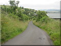
Auchtenny Brae
The C413 (Perth and Kinross) road heading steeply downhill, northwards at Auchtenny.
Image: © Scott Cormie
Taken: 23 Jul 2019
0.02 miles
2
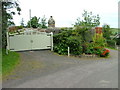
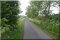
Gates to Auchtenny
On the Path of Condie to Milnathort road.
Image: © Dave Fergusson
Taken: 1 Sep 2010
0.12 miles
3
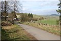
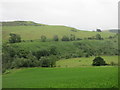
Auchtenny
Auchtenny farm sits below Struie Hill and above the Chapel Burn
Image: © Jim Bain
Taken: 25 Apr 2006
0.15 miles
4
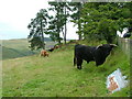
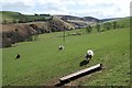
Cattle at Auchtenny
Baulk Hill can be seen through the trees.
Image: © Dave Fergusson
Taken: 1 Sep 2010
0.15 miles
5
By Auchtenny
Looking across the fine grazing land by Auchtenny and southwards up the Chapel Burn.
Image: © Jim Bain
Taken: 25 Apr 2006
0.16 miles
6
Path of Condie to Stronachie road
Another long uphill, typical of the Ochil Hills.
Image: © Richard Webb
Taken: 3 Jun 2018
0.20 miles
7
Bracken covered slope
The bracken covered lower slope of the western side of Whitehill Head, viewed from the roadside to the west.
Image: © Scott Cormie
Taken: 23 Jul 2019
0.21 miles