IMAGES TAKEN NEAR TO
Forgandenny, PERTH, PH2 9DN
Introduction
This page details the photographs taken nearby to PH2 9DN by members of the Geograph project.
The Geograph project started in 2005 with the aim of publishing, organising and preserving representative images for every square kilometre of Great Britain, Ireland and the Isle of Man.

There are currently over 7.5m images from over14,400 individuals and you can help contribute to the project by visiting https://www.geograph.org.uk
Image Map
Images are licensed for reuse under creativecommons.org/licenses/by-sa/2.0
Notes
- Clicking on the map will re-center to the selected point.
- The higher the marker number, the further away the image location is from the centre of the postcode.
Image Listing (23 Images Found)
Images are licensed for reuse under creativecommons.org/licenses/by-sa/2.0
Image
Details
Distance
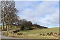
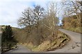
3
To Dunning
This unclassified hill road above Pathstruie is lined here with majestic beech trees
Image: © Glen Breaden
Taken: 31 May 2011
0.06 miles
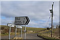
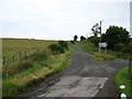
4
Approaching a junction of roads near to Mains of Condie
Looking eastward.
Image: © Peter Wood
Taken: 30 Sep 2017
0.06 miles
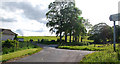
7
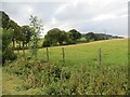
Grassland, Mains of Condie
The trees are beside the road to Dunning.
Image: © Richard Webb
Taken: 1 Oct 2013
0.09 miles
8
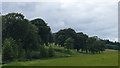
Field boundary near Struie View
The road bounds this field on two sides although from this angle it is entirely hidden by the trees also at the field edge.
Image: © Doug Lee
Taken: 21 Jun 2014
0.11 miles
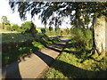
10
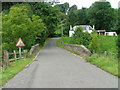
Bridge over the Water of May
At Pathstruie. The road ahead leads to Dunning and Forgandenny.
Image: © Dave Fergusson
Taken: 1 Sep 2010
0.14 miles