IMAGES TAKEN NEAR TO
Rhynd, PERTH, PH2 8QD
Introduction
This page details the photographs taken nearby to PH2 8QD by members of the Geograph project.
The Geograph project started in 2005 with the aim of publishing, organising and preserving representative images for every square kilometre of Great Britain, Ireland and the Isle of Man.

There are currently over 7.5m images from over14,400 individuals and you can help contribute to the project by visiting https://www.geograph.org.uk
Image Map
Images are licensed for reuse under creativecommons.org/licenses/by-sa/2.0
Notes
- Clicking on the map will re-center to the selected point.
- The higher the marker number, the further away the image location is from the centre of the postcode.
Image Listing (6 Images Found)
Images are licensed for reuse under creativecommons.org/licenses/by-sa/2.0
Image
Details
Distance
1
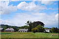
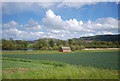
Wester Rhynd
The former farmhouse with its outbuildings and cottages, which is no longer operational as a farm. However the land is still cultivated but from another source.
Image: © Glen Breaden
Taken: 30 May 2011
0.06 miles
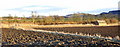
2
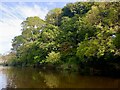
River Earn, Wester Rhynd
After the entry bend into a massive meander around Fittie Haugh.
Image: © Richard Webb
Taken: 7 Jun 2022
0.09 miles
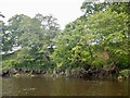
4
Wooded banks of the Earn
The Earn passing Wester Rhynd.
Image: © Richard Webb
Taken: 7 Jun 2022
0.19 miles
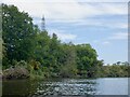
5
Fittie Haugh
Erstwhile salmon fishers' bothy (or lodge according to the map!) on the River Earn with such a quaint name.
Image: © Glen Breaden
Taken: 30 May 2011
0.22 miles
6
Salmon fishers' bothy at Fitty Haugh, River Earn
This is larger, but of similar construction, to the bothy upstream at Carey Hole. The Fitty Haugh fishings have not been worked for many years and there is now (2011) no netting for salmon on the River Earn.
Image: © Iain A Robertson
Taken: 9 Feb 2010
0.23 miles