IMAGES TAKEN NEAR TO
Tayside Place, PERTH, PH2 7UB
Introduction
This page details the photographs taken nearby to Tayside Place, PH2 7UB by members of the Geograph project.
The Geograph project started in 2005 with the aim of publishing, organising and preserving representative images for every square kilometre of Great Britain, Ireland and the Isle of Man.

There are currently over 7.5m images from over14,400 individuals and you can help contribute to the project by visiting https://www.geograph.org.uk
Image Map
Images are licensed for reuse under creativecommons.org/licenses/by-sa/2.0
Notes
- Clicking on the map will re-center to the selected point.
- The higher the marker number, the further away the image location is from the centre of the postcode.
Image Listing (14 Images Found)
Images are licensed for reuse under creativecommons.org/licenses/by-sa/2.0
Image
Details
Distance
1
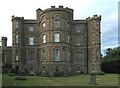
Pitfour Castle
Pitfour castle was designed by Robert Adam and built in 1764. It is divided into several privately-owned apartments now.
Image: © Rob Burke
Taken: 7 Sep 2003
0.10 miles
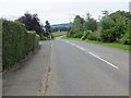
2
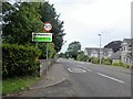
Entry to St Madoes from the east
30mph sign; near an access road (off left) to Pitfour Castle.
Image: © Stanley Howe
Taken: 28 Jun 2016
0.15 miles
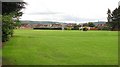
3
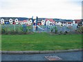
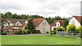
Children's play area
This recently-built estate at St Madoes has a good large green in the centre.
Image: © Rob Burke
Taken: 26 Nov 2005
0.16 miles
4
New housing under construction at St. Madoes
'Gowrie Way'.
Image: © James Denham
Taken: 2 Jun 2010
0.16 miles
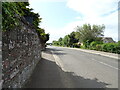
5
Cairnie Road leaving St Madoes
Looking south-eastward.
Image: © Peter Wood
Taken: 22 Jun 2019
0.18 miles
6
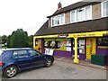
St Madoes Store
Village shop. 2010 view: Image
Image: © Richard Webb
Taken: 30 Aug 2014
0.18 miles
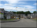
9
Madoch Square
Recent housing development in St Madoes.
Image: © Richard Webb
Taken: 25 Aug 2010
0.21 miles
10
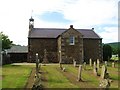
St. Madoes and Kinfauns Parish Church
Situated in St. Madoes; Kinfauns closed nearly 30 years ago.
Image: © James Denham
Taken: 2 Jun 2010
0.21 miles